


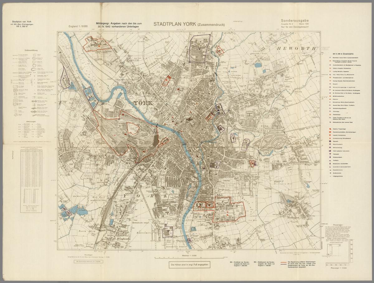

A staple of York since 1937, Bettys Tea Room now finds itself at the centre of an unexpected mystery, after a rediscovered map appears to mark it alongside Nazi bombing targets - at least at first glance.
The map, a British Ordnance Survey street map marked up by Nazi intelligence in the 1940s, has recently resurfaced online.
Interestingly, alongside strategic and military targets, a number of cultural landmarks are marked prominently.
Recommended reading:
Famous York landmarks, including York Minster, York Library, and The Yorkshire Museum, are marked with a red star.
The map’s key identifies them as “Kunstsammlung” and “Kulturdenkmal” - German words for art collection and cultural monument.

Another star appears near Bettys on the map, raising questions about why the Nazis marked this corner of York.
Were they planning to cut off the supply of tea and cake to the population of York, or is it simply down to the tearoom’s civic neighbours?
John Shaw, Chairman of the Yorkshire Architectural & York Archaeological Society, suggests it was the latter.
He said: “Quite close to Bettys is the Guildhall of the Council Offices, which was the central control of the city during any air raids.
“The other control centre was the former telephone exchange just a few metres away.”
The Guildhall was targeted as part of the Baedecker raids in April 1942, leaving the building gutted by fire.
Bettys, meanwhile, didn’t escape the war undamaged.
When contacted for comment, Bettys provided information from its website stating it was hit by an incendiary bomb in 1942.
The café avoided major damage thanks to the quick actions of an off-duty van driver serving as a fire watcher.
It was also widely known to be a hotspot for RAF and Canadian Air Force pilots, with its basement bar - known as “The Dive” - attracting servicemen stationed nearby.
“There were some very interesting straight raids which can't be easily explained"
John explained there had been examples of raids across Yorkshire targeting similar sites.
He said: “There were some very interesting straight raids which can't be easily explained.
“In 1940 there was one in Harrogate with one bomber and two bombs hitting one of the hotels, which just happened to be a meeting place for some RAF bigwigs at the time.
"That's not a coincidence; it’s obviously good intelligence.”
Another curious marking appears at the Rowntree’s Cocoa Works, highlighted alongside military barracks, hospitals, and gas works - an unexpected companion for a chocolate factory.
However, the reality here is less mysterious than it first appears.
John said: “Rowntree's set up an umbrella company called County Industries Limited, so the chocolate factory was being used for shell manufacturing - armaments.
“Knowledge like that, although kept secret and embargoed, would get out.”
Despite this, he confirmed there had been no raids specifically targeting the chocolate factory.
He also confirmed that other locations marked on the map lined up closely with sites targeted during bombing raids in 1941.
He said: “There was a night raid and they were bombing right across what we know as The Groves.
“The Stuka bombers were clearly trying to hit the gas works.”
So while it seems the Nazis weren’t plotting to wipe out afternoon tea and KitKats, the map does reveal how closely culture and conflict can sit side by side - sometimes just a scone’s throw apart.


Share