


GEORGE WILKINSON enjoys a calm, quiet and misty walk in the Hawnby Hills.
HAWNBY was calm, quiet and misty in its dip, warm on the cusp of winter with a sky the grey of the woodpigeons and the smooth hills around all blurred.
We climbed, sheep were settled and higher up the cattle too, and now and then a single leaf would fall.
On the tops it was a bit of a shuffle around Sunnyside Farm, where there is a zone of path junctions; usefully, the way marking is similarly intricate.
Pigeons circled fast over Gower Dale. We took no time to do the steep downhill which comes out at a pretty joining of crystal, spring-fed, watercress streams. It was slow on the steep up to a farm named Dale Town, where they offer fossils costing from five pence to a £1. And from Dale Farm steep up again, to make a total 500 feet of climbing, and now there are favoured views of the principal and shapeliest of the Hawnby Hills.
We reached Murton Heights, quite a place, with a medieval history, and Murton Grange, a big white farmstead.
The Heights are flat, a dozen or so fields, and driven through them a track called Ox Pasture Lane. Now we stretched our legs, and it was speedy the rest of the walk.
It should have been a serene, plain, wide-sky track, with the ‘V’ of geese for a thrill, the fat dense sloe berries for fruitfulness; a mellow mile or more and an old stone barn rested, but the pheasants and partridge rather clattered that.
We turned and started back, and just for a step or two there was a very good view of the sweetly shaped Coomb Hill that rises behind Hawnby, two miles off and hidden.
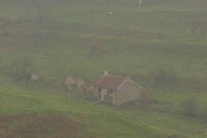
The mile first was on forest track. We saw a small deer, and here a flurry of breeze that lasted perhaps ten seconds and brought down a curtain of colour from the fringe of broadleaves. The last mile was over rolling pasture above the River Rye, and in the opaque fading light, smoke from a Hawnby chimney blended with the mist.
Directions
When in doubt look at the map. Check your position at each point. Keep straight on unless otherwise directed.
View a map of the Hawnby Hills country walk>>
1. Left from village hall car park to road.
2. About 100 yards before church, path on left (sign) to footbridge over River Rye and immediately right, 100 yards, gate (waymark) into woods, path uphill. Fieldgate (no waymark) into field, 50 yards, waymarked post and cross field, stile and by field boundary to your right, waymarked post in corner and uphill with boundary to your left, 200 yards.
3. Stile on left (old waymark on far side) and by boundary to your left, contour. Fieldgate on left (two waymarks, fingerpost Dale Town) and immediately right below large barns, fieldgate after barns, left to track, ignore a right, 50 yards, pass fingerpost (bridleway).
4. Cross track (fingerpost Dale Town), across grass for 50 yards, fieldgate (blue waymark) into field, downhill, fieldgate, 100 yards, fieldgate on right (blue waymark) and immediately left by stream 100 yards, gate (blue waymark), downhill, fieldgate, slab bridge at valley bottom. Straight uphill and join grass track, 5. Fieldgate (waymark) into farm yard, fieldgate (waymark) between buildings, through yards, fieldgate out (waymark), gate/cattlegrid (waymarks) and 1 o’clock uphill.
6. At scrub on hillside, grassy track on right (no sign).
7. At junction before tree and wood, left to wide stone track (blue waymarked post). Fieldgate, cross road, road (signed Murton Grange), mown verge. 8. About 100 yards after bungalow, gate on left (bridleway sign) to track. At wood, keep to track then path on left-hand edge. Fieldgate into field and grass path/track to right of doubly-fenced new hedge. Fieldgate, cross grass to wood then right (waymarked post). Join track.
9. Pass stone barn (waymarked post) and downhill 150 yards then leave track at gateway (felt tipped arrow mark), 20 yards, sharp left (waymarked post) to grass track downhill.
10. Grassy track on left (three-way fingerpost) towards woods, 20 yards, fieldgate to wood edge track 11. At fingerpost opposite steps on left, take path downhill on right, 50 yards, waymarked post, stile, cross field, stile/fieldgate, cross road, stile/fieldgate (sign), 10 o’clock, 200 yards, stile/fieldgate on left to path 1 o’clock across field via trees (fingerpost), stile (waymark) below fieldgate, stile/fieldgate, 1 o’clock, stile and right to road.
Fact file
Distance: Six miles.
General location: Hawnby Hills.
Start: Hawnby.
Right of way: Public.
Dogs: Legal.
Date walked: November.
Road route: Various.
Car parking: Car park behind village hall (honesty letterbox).
Lavatories: None.
Refreshments: Tea room and inn at Hawnby.
Tourist and public transport information: Helmsley TIC 01439 770173.
Map: Drawn from OS OL26 North York Moors western.
Terrain: Hills.
Difficulty: Moderate.
Please observe the Country Code and park sensibly. While every effort is made to provide accurate information, walkers set out at their own risk.


Comments: Our rules
We want our comments to be a lively and valuable part of our community - a place where readers can debate and engage with the most important local issues. The ability to comment on our stories is a privilege, not a right, however, and that privilege may be withdrawn if it is abused or misused.
Please report any comments that break our rules.
Read the rules hereComments are closed on this article