
GEORGE WILKINSON skirts the famous ruins of Rievaulx on a seven-mile walk with plenty to see and only a minor car-parking hazard to worry about.
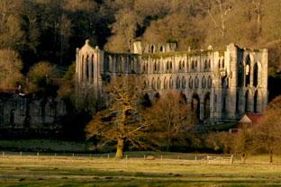
RIEVAULX has been dominated by the abbey for near a thousand years. And English Heritage has almost a seasonal monopoly on car parking.
With a wary eye on the sliding steel barriers on their car park, we checked opening times, finding them to be 10am to 4pm (or until 6pm from April). Four o’clock was cutting it fine, so we tucked in somewhere else in the village. The alternative start for this route would be Old Byland.
The abbey has the monopoly of food on this route and were doling out free morsels of delicious lemon curd tart, washed down with shots of ginger wine.
Fuelled, we headed upriver to the songs of a local thrush, by the hazel woods curtained with catkins and under the alders and the softest of suns. “Everywhere peace, everywhere serenity,” as wrote Abbott St Aelred 800 years ago.
From Tylas Farm, we left the valley and climbed to Tylas Barn. Here there is a super view all the way back to the abbey. Three buzzards circled, but the 50 crows in a tree did not respond, except for a few and rather half-heartedly, almost with peace and serenity.
Five fields were hare sprinting country. Old Byland is a hamlet of a farm and a dozen stone houses around a green.
From here, Low Gill runs for a mile, forming a pheasant shooting valley, with wooded sides; on the grass bottom, a gentleman was collecting the litter of plastic plugs from spent shotgun cartridges.
A ‘penny a plug’ he pays schoolchildren. In the monks’ time the money was in sheep.
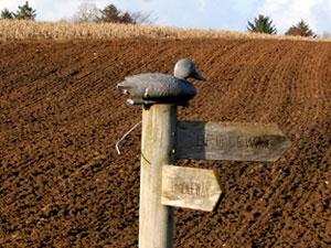
Then, after a climb out, there’s another farm and more high fields and then, despite a waymark surmounted by a plastic decoy duck, we found a pond where 50 real mallards floated.
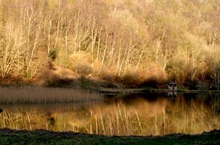
We’d dropped through Spring Wood into Nettle Dale which is threaded by the Cleveland Way and where the four sequential fisherman ponds were mirrors.
Lift your eyes from the riverside aconites and snowdrops to the Tuscan Temple on high and scan those glorious abbey arches.
St Aelred thought Rievaulx had “a marvellous freedom from the tumult of the world”; perhaps this could be yours if, coming in late, you find your motor blocked by a barrier.
A night under the arches could be called for.
Directions
When in doubt look at the map. Check your position at each point. Keep straight on unless otherwise directed.
1. Right from abbey to road through village, uphill. Left (no sign) to initially metaled track by Methodist Chapel and opposite church, ignore fork left to house, uphill.
2. Fork left to fieldgate (no sign), track downhill.
3. Bridge over River Rye, 200 yards, stile/fieldgate (fingerpost Hawnby) on right, path through field, 600 yards, snickelgate, steps, duckboards above river. Through field.
4. Fieldgate and right to metalled track.
5. At tracks junction near farm, left uphill (waymark). Fieldgate, pass barns, fieldgate (waymark).
6. At track bend and head of valley, stile on right (fingerpost Old Byland), by fence to right, stile, stile, cross track, stile, stile (nearby waymark). Left at field corner (fingerpost), gateway.
7. Ladderstile and right to road, road on left (signed Cold Kirby), down through village and just round corner.
8. Fieldgate on left (bridleway sign) before lane on right, grass for 100 yards then path angles gradually downhill through wood to and then along valley floor.
9. At T-junction with concrete track, right, uphill, plain track. At top, right (fingerpost), through yard, 70 yards, left between barns (waymark), 50 yards, fieldgate (waymark), cross field.
10. Fieldgate (waymark far side) and right, field-edge, fieldgate (waymark), field-edge.
11. Fieldgate at head of valley, 20 yards and before fingerpost left to track down through bottom of valley.
12. Right to track at pond, ford spring, fieldgate (waymark), track, gated footbridge, gate/fieldgate, ten yards, left, (waymark), 20 yards, gate (waymark, fingerpost), large stepping stones that can be bypassed.
13. Left to track (fingerpost). Gate and left to road (fingerpost), over Rievaulx Bridge and left to Abbey.
Fact file
Distance: Seven miles.
General location: North York Moors.
Start: Rievaulx.
Right of way: Public.
Dogs: Legal.
Date walked: February 2011.
Road route: Via B1257. Moorsbus from Helmsley in season.
Car parking: Rievaulx Abbey £4 or Old Byland.
Lavatories: Rievaulx Abbey.
Refreshments: Rievaulx Abbey.
Tourist and public transport information: Helmsley TIC 01439 770173.
Map: Drawn from OS Explorer OL26 North York Moors western area.
Terrain: Valleys and uplands.
Difficulty: Moderate.
Please observe the Country Code and park sensibly. While every effort is made to provide accurate information, walkers set out at their own risk.


Comments: Our rules
We want our comments to be a lively and valuable part of our community - a place where readers can debate and engage with the most important local issues. The ability to comment on our stories is a privilege, not a right, however, and that privilege may be withdrawn if it is abused or misused.
Please report any comments that break our rules.
Read the rules hereComments are closed on this article