
WEST Lutton sits in the Wolds, on a lot of chalk. The little village has a stream, the only proper one in the High Wolds. Near the church and pub, there is a large, rare, 1866, circular, Pickering-made, iron, hand cranked water pump.
The stream, called Gypsey Race, was dry, its yard-wide bed cracked; not a drop since the snow melt, said a nonchalant gardener.
A few minutes later, we bumped into a trio of walkers from Driffield and were informed of a version of a legend concerning Gypsey Race that, if the stream flows above ground on the 20 miles from its source five miles west of here to its outlet in Bridlington, it portents the “waters of woe”.
More tangibly, the race runs along, or under, the Great Wold Valley, a place of prehistoric activity, and nice to walk down, shallow, wide and grassy. St Mark’s Day flies bumbled around the air, black with dangling legs, hatched a couple of weeks late for their allotted day.
Rooks left an ash tree, Church Garth Hill brought the view of a church spire, and water flowed in the race, minty clear and enough to fill a bath in five minutes. By the time we reached the village of Kirby Grindalythe, the flow had doubled perhaps.
We took a back road, to climb, and met only a handful of open-topped sports cars on their summery slow way. And we reached the ridge. This has a top line of beech trees; the wood is 50 yards deep or more and a mile long.
We walked the sunny south side of the beech, with birdsong and bumble bees and a thousand bright blue eyes of speedwell flowers.
The Driffield trio came round again and this time gave us details on a new route. Time to marvel at tower-block stacks of 3,000 potato crates.
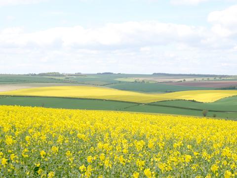
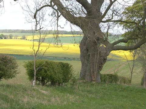
Some distance along the wood, we cut through to the north side and the shade and the wind. But here the landscape was most vivid; the fields were saturated patterns of rape yellow.
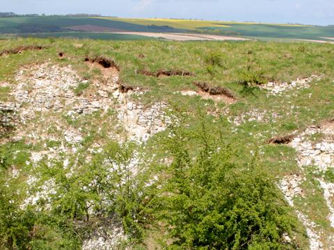
There is a trig point at 515 ft. You can see the North York Moors to the north. And next to the trig is a little old quarry hole, still a hole, not filled with farm rubbish; it has the best rock face on the route, that deep fractured chalk. The rock makes bright any bare fields and patches in crops.
A skylark sang, a medium-sized wind turbine spun at one revolution per second and we descended into West Lutton on Sheepwalk Lane, a sunken track, for a delightful woe-free walk.
Fact file
Distance: Five miles.
General location: Yorkshire Wolds.
Start: West Lutton.
Right of way: Public.
Dogs: Legal.
Date walked: May 2010.
Road route: Various.
Car parking: Roadside in West Lutton.
Lavatories: None.
Refreshments: Three Tuns, in West Lutton.
Tourist and public transport information: Malton TIC 01653 600048.
Map: Drawn from OS Explorer 300.
Terrain: Valley and ridge.
Difficulty: Moderate.
Please observe the Country Code and park sensibly. While every effort is made to provide accurate information, walkers set out at their own risk.
Directions
When in doubt look at the map. Check your position at each point.
Keep straight on unless otherwise directed.
1. From pub, left through village. On bend, lane on left for 100 yards and pass pumping station (campsite signs).
2. Grass track/path on right (sign), fieldgate, gate, join stone track, straight on at bend into field above farm, fieldgate (waymark), fieldgate (waymark).
3. Gate (waymark), 30 yards, right, 50 yards, left and by stream.
4. Left at field corner, 25 yards, gate on right, path, fieldgate (waymark), fieldgate (waymark), 1 o’clock to gate, track on right, ten yards. Left to road in village.
5. Left to road/verge (Sledmere 2½), uphill.
6. At top, at far edge of wood, metalled drive on left (fingerpost bridleway, Squirrel Hall Farm). Pass farm yard.
7. Track swings left through trees then immediately right.
8. Track on right 100 yards to trig point only.
9. Track swings left and steepens downhill.


Comments: Our rules
We want our comments to be a lively and valuable part of our community - a place where readers can debate and engage with the most important local issues. The ability to comment on our stories is a privilege, not a right, however, and that privilege may be withdrawn if it is abused or misused.
Please report any comments that break our rules.
Read the rules hereLast Updated:
Report this comment Cancel