
RICCAL Dale is the medium-sized valley that runs north from near Helmsley to the moors.
A current Road Closed sign is irrelevant. We drove up to Riccal Dale, passed through the village of Carlton and parked just before the moors at a place where there is only a tiny church and a schoolroom, which is now a house.
We headed back down the dale, a pleasant valley, admired the cows, horses and sheep at Howl Wood Farm, but had half an eye to the sky, nose to the breeze, hoping the day would brighten or there would be the thrill of a storm. The most drama was watching big worms pop out of an enlarging mole hill; what a year for moles.
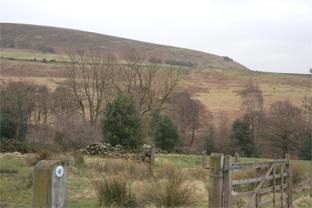
It was nice to see a new bridge over a ford, made in the National Park’s design of a traditional timber superstructure strengthened by a substructure lattice of galvanised steel tube. This bridge isn’t marked up on the new 2009 OS map, but the fact that we touch on the Tabular Hills Walk is.
A robin sang from a thorn tree, other thorn have been chopped to regenerate and re-hedge; there is new fencing, new gates, a refurbished countryside.
A couple of miles brought us to Hasty Bank Farm, tidy these days and a place I’m fond of because a friend lived here and it was the isolated venue for our late-night band practice. I remember being glad not to play a heavy bass guitar because the track that leads out and up to the outside world is long, rough and steep.
Once it was lit by a summer’s night glow worms, once a gamekeeper threatened to “lamp-post” me.
The climb warmed us and on the top we had our sandwiches and watched the lapwings whirl.
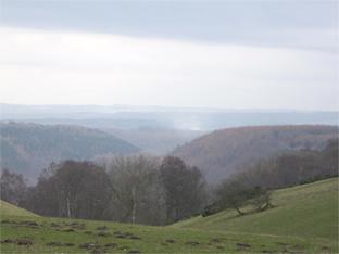
Now our route hugs the rim of Pockley Rigg, where the land drops steep, is gnarled by oaks and curtained silver by birch. Through a gap were buzzards, three or four, cruising round and round above the tree tops and the pasture with hardly a brush from their broad wings.
This is dangerous air for raptors, and sure enough there was a pheasant pen the size of a football field where last season’s birds would have been fattened, then to be ushered off an edge to guns below.
But it was peaceful as we crossed the head of a side valley, caught framed views south to the Howardian Hills and started on very quiet dead-end road, the final mile of it before it becomes a green lane.
The light was failing, the day softening pre-dusk. To break the spell, a hundred rooks flew out, circled manically and very noisily for less than 30 seconds and then went quiet and disappeared for one hopes a good night’s rest. A minute’s rain shuffled a hatch of midge; so much for a sunset.
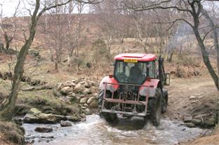
At the last farm we took in the moorland views to the north and tracked down to ford Bonfield Gill.
At the stream a farmer was sawing up flood-toppled trees and I said in jest: “Why don’t you do something useful and make us a bridge?” He smiled knowingly and said: “There is one.” There isn’t on the OS map, but sure enough, nearby, just as he pointed, there is. So no rock-hopping needed and many thanks for the info.
This corner at Throstle Nest is as pretty as its name. By the stream is a garage-sized root plate of a fallen oak, if not attended to by the chainsaw.
As we walked past Church Plantation, roosting pigeons clattered out, the last action of their day, the last of ours.
Directions
When in doubt look at the map. Check your position at each point.
Keep straight on unless otherwise directed.
1 From churchyard, south on road 200yds. Path on left (bridleway sign), across verge, 50 yards, fieldgate into field, one o’clock via conifers.
2 Fieldgate (waymark), pass fieldgate on left, by fence to your left.
3 Fieldgate on left (waymark), 20 yards, right downhill by wall (waymarked post), footbridge and stile over stream, right ten yards, left uphill on stone path 100 yards, left uphill in field 100 yards via waymarked post, path angles right gently uphill and ignore a faint left fork after 100 yards.
4 Wooden fieldgate (blue waymark), 50 yards and join track (fingerpost). Fieldgate into farmyard (waymark), track, fieldgate out (waymark), track. Fieldgate. New fieldgate and track downhill between line of old hedgerow trees with new fencing to your right, ford, track, stepstream, 2 fieldgates, (old ‘link’ waymark) track steep uphill through wood .
5 At top of hill, left to track (fingerpost), 100 yards, ignore signed fieldgate, join path/track between wood and fence (no sign). After 500 yards right of way kinks to follow grassy spur currently with pheasant pen, usage route straight on. Keep by wood, ignore a right fork.
6 Fieldgate into field (waymark far side), 50 yards, gate (waymark), gate and 2 o’clock across large field towards farm (waymark).
7 Fieldgate and left to dead-end road. Fieldgate, road continues.
8 Just before bend to farmhouse, stile on left (fingerpost) and join track downhill by wall to your left.
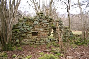
9 Where wall ends and before bend, fieldgate on left (no sign), 1 o’clock 100 yards into trees, track 200 yards, right downhill to pass ruins 100 yards, metal fieldgate and footbridge, 1 o’clock uphill, stile and immediately left.
10. Stile/fieldgate (waymark), stile/fieldgate, stile/fieldgate by farm and leave track and straight on by edge of conifer wood (waymarked post).
Stile/fieldgate. Gate (waymark), by fence to your right to church, track to road.
Fact file
Distance: Five miles.
General Location: North York Moors.
Start: Near church.
Right of way: Public.
Dogs: Legal.
Date walked: March, 2009.
Road route: From Helmsley, north via Carlton.
Car parking: Roadside near telephone box/postbox/church/The School House.
Lavatories: None.
Refreshments: Helmsley.
Tourist and public transport information: Helmsley TIC 01439 770173.
Map: Drawn from the new OS Explorer OL26 North York Moors western area.
Terrain: Valley and tops.
Difficulty: Moderate.
Please observe the Country Code and park sensibly. While every effort is made to provide accurate information, walkers set out at their own risk.


Comments: Our rules
We want our comments to be a lively and valuable part of our community - a place where readers can debate and engage with the most important local issues. The ability to comment on our stories is a privilege, not a right, however, and that privilege may be withdrawn if it is abused or misused.
Please report any comments that break our rules.
Read the rules here