


CARLTON, the one in Coverdale, is a pleasant village, notable, and take note walkers, for a village hall car park we can use. It has an honesty box.
Our first impressions were made memorable because we irritated a local with our apparent discourtesy. We had missed the yellow car park sign, so our apologies.
Less humble is a large 19th century stone plaque that a Henry Constantine, a gentleman I believe, set on to his house. This self-proclaimed ‘Coverdale Bard’ makes mention of ‘endurance’. Marie Hartley and Joan Ingilby wrote in 1956 that Coverdale was the “most secret and hidden of dales” but that it had “seen the passage of all sorts of people” and had “Love Feasts”.
We began our climb of chapel, waterfall and pastures, broken barn and rattling becks. A new edition of the Ordnance Survey map of the northern and central Dales gave us that extra confidence. After a bit of previously pushed-down wire and a compass setting, we were on to Melmerby Moor.
We had found the old ‘green lane’, which is really nowt but a path, and not for the snow.
Snow there was, lingering in lumps, but 500-ft higher, on the bulge of Penhill that stood close and above us, to one side.
The moor is a mosaic of heather in its various stages, grasses and rush. It took us up to 1,200 feet, the brow, and the first thing to catch the eye the other side was Leyburn in Wensley-dale. The second thing was the smooth, white, bent railings that guide fast horses. The main gallops are on Middleham Low Moor, a couple of miles east, just before the town of Middleham. A twin rotor Chinook helicopter thudded down Wensleydale. We crossed Middleham High Moor, or Common as it is named on old maps, above and parallel to a gallop. Galloping is done in the morning. Our grass varied from turf to very tufted, the sort of tufts life over-winters in.
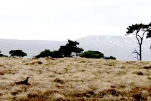
Talking of life, this is when our route livened up. First, in a dip in a roller coaster of pasture, were a dozen greylag geese at a pond a few hundred yards away. Their alarm calls were loud, their behaviour typically calm. On a rise with trees, a hundred mixed gulls and crows methodically fed on a pasture. As we crossed Hen House Hill, a place that must always have been most inhospitable to hens, the grouse posed and a small bird, probably a pipit, led us on a teasing walkabout. A single rotor chopper did a couple of low, tight turns.
The landscape coming down brought a wish-we-were-there moment, to the southwest, Kettlewell way, to fell ridges picked out by the snow and gullies packed white against black rock.
But we had much enjoyed our day and increasingly liked the village of Melmerby as we sloped in. Its first bench of curled iron, its rookery simmering with spring, another bench set in a wall, another by the public tap, plus a red phone and letter box, twin pinfolds for sheep and by them a mounting block for riders of horses.
That just left the road. For somewhere so out of the way we caught a bit of a 4x4 rush hour, but just a convoy and slowed by a front loader and a tractor and so that was all right. The wall-trained fruit was a pear.
Directions
When in doubt look at the map. Check your position at each point. Keep straight on unless otherwise directed.
1. Left from village hall car park and head west through village. At Wesleyan chapel, now Methodist church, track on right uphill (no sign). Before waterfall, fieldgate on right and stony track peters out, uphill.
2. Fieldgate by roofless barn and keep by wall to your right, track, ford, gateway, 50 yards. Fieldgate and left uphill on faint path for 200 yards, step over wire fence at narrow gap between two close fenceposts and remnants of stile, path at one o’clock for 300 yards then pick up wall to right, 200 yards.
3. Fieldgate to moor, grass track for 50 yards, cross track, ignore track forking left along grouse butts, 100 yards, ford, stone track then path/track. Cross another track near road.
4. Left to road, 300 yards, fieldgate on right to grassy track at one o’clock. Step/climb over newish wooden fence by wall. Keep by wall to your right.
5. Ladderstile on right to pastures, 50 yards diagonally stile, 11 o’clock to, ladderstile (old fingerpost propped up), ten o’clock over large hillocky field, field-gate (fingerpost), one o’clock.
6. Gated squeezer and stile to path across moor (waymark posts fallen, some little cairns).
7. Left to road downhill, right at junction in Melmerby. Right at junction (signed Carlton).
Fact File
Distance: Four-and-a-half miles.
General location: The Yorkshire Dales.
Start: Carlton.
Right of way: Public, and a common.
Dogs: Legal, but remember the horses, birds etc.
Date walked: February, 2009.
Road route: Via Middleham or Leyburn.
Car parking: Village hall.
Lavatories: None.
Refreshments: The Foresters Arms at Carlton.
Tourist and public transport information: Leyburn TIC: 01748 828747.
Map: Based on the new OS Explorer OL30 Yorkshire Dales northern and central areas.
Terrain: Mostly moor.
Difficulty: Moderate if fine.
Please observe the Country Code and park sensibly. While every effort is made to provide accurate information, walkers set out at their own risk.


Comments: Our rules
We want our comments to be a lively and valuable part of our community - a place where readers can debate and engage with the most important local issues. The ability to comment on our stories is a privilege, not a right, however, and that privilege may be withdrawn if it is abused or misused.
Please report any comments that break our rules.
Read the rules here