

AMPLEFORTH, but not the abbey, the clergy and the public school, that’s a mile to the east – instead we are concerned with the village of stone, wisteria and two pubs.
Plus clematis and caravans, the latter on their designated migration route. Well, two came one way and one came the other and then came the reversing, if you can call it that; more like ten minutes of slewed, stuttering meanders and frozen, familial trauma. One can only hope the Caravan Club offer counselling.
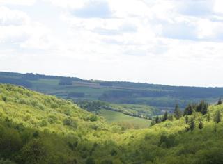
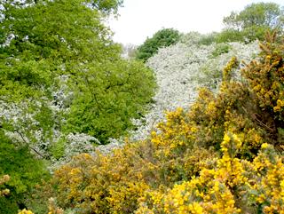
Our little journey, one of discovery, went smoothly up a rise for the views of Ampleforth’s wide valley. A local woman stopped to find me peering at the verge. “Bulrushes,” she said. “We are very springy around here.” And colourful here too, the sky was pasted with blossom, the pastures bright with flowers, we did indeed come across some gin clear flows and a pond humming with insects, and a ten-spot ladybird.
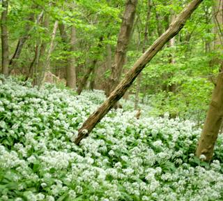
But essentially we had a little valley called Shallow Dale to find somewhere in a bank of woods. Its entrance was a discreet break in the oaks, and then a sharp climb, all pale with ransoms, brought us to the open dale. For a moment it blackened with crows, then we were in flower pastures and then grassier pasture as we took its half a mile.
At the end is High Woods Farm, now with a conservatory. Up above it is a splendid stone bench and, after a sandwich, we looked for a cave in the woods, thinking ‘monk’ but didn’t find it.
You might be tempted by the public route up Royalty Slack. Beyond to the north is College Moor, but that’s mostly out of bounds.
The return is very simple and easy, on a metalled drive that halfway along becomes a public highway. As it only connects with High Woods Farm, there was merely a Landrover as traffic. Never have I seen the centre line vegetation on a back road with such a high species count, except near the municipal salt boxes. We got our money’s worth and came nicely out again for the village and its valley.
Fact file
Distance: Four miles.
General location: North York Moors.
Start: Ampleforth.
Right of way: Public.
Dogs: Legal.
Date walked: May, 2010.
Road route: Various.
Car parking: Roadside parking in Ampleforth.
Lavatories: None.
Refreshments: The White Horse and the White Swan Tourist and public transport information: Helmsley TIC 01439 770173.
Map: Drawn from OS Explorer OL26 North York Moors western.
Terrain: Valley.
Difficulty: Quite easy.
Please observe the Country Code and park sensibly. While every effort is made to provide accurate information, walkers set out at their own risk.
Directions
When in doubt look at the map. Check your position at each point.
Keep straight on unless otherwise directed.
1. Pavement west out of village towards Wass, then verge, crest hill.
2. Path on right in trees (sign) and stile into field, angle left diagonally across field on faint path keeping well below scrub and woods to angle up slightly to briefly go through trees at corner.
3. Footbridge and stile (waymark) out of trees, 11 o’ clock, pass below ruined hut, stile (waymark), 150 yards, cross drive with two stiles (waymarks), 1 o’ clock.
4. Gated footbridge, 100 yards, right uphill.
5. Stile into wood (waymark), 200 yards uphill, path swings left then right and under conifers.
6. Stile (waymark) into field, keep near wood to right, fieldgate (waymark), 1 o’clock, stile/fieldgate (waymark). By house, left uphill (fingerpost) to stone bench below wood, return and pass last building.
7. Gate and left to drive, becomes road. Left to road to rejoin outward route.


Comments: Our rules
We want our comments to be a lively and valuable part of our community - a place where readers can debate and engage with the most important local issues. The ability to comment on our stories is a privilege, not a right, however, and that privilege may be withdrawn if it is abused or misused.
Please report any comments that break our rules.
Read the rules here