
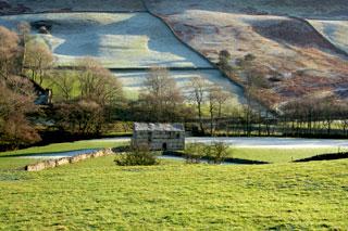
WEST Burton is a ‘show village’ of the Dales, wrote Marie Hartley and Joan Ingilby in 1956. It is set in the mouth of Waldendale, otherwise named Walden, which is a Wensleydale side valley of significance. They wrote that “to make a circuit of the dale on foot is an unforgettable walk”, and this we did.
All was cheer and tea from the village café, except that my navigator had forgotten her thick socks and was not amused by an engraved flagstone that informs that here, in the old days, lived a poet, a violin maker and, most pertinent, a woolly sock maker.
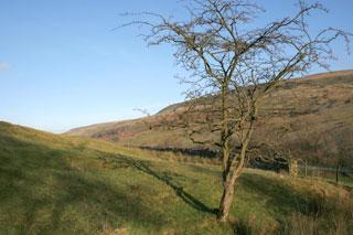
We left frost prints on the village green, negotiated quoits pitch and icy swings and set off into Walden Dale on a back lane that soon splits into two, one for each flank. The valley runs north to south, about 15 degrees west of south and hence was sunlit nearly all afternoon.
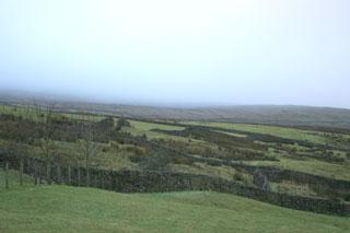
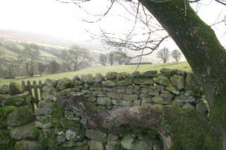
But frost persisted in hollows as a wide silver strip in the shadow of the dry-stone walls. The walls have spring-loaded squeezer gates, dozens of them, that set the tempo, but are not too slowing, once one has perfected the squeeze and shuffle. Similarly the side streams required mostly a single stride.
At a sandwich stop rock we watched and listened to the river, the flock of rooks, and a Land Rover. The valley is V-shaped, cut by water and has as Hartley and Ingleby wrote “no space at all for villages”; they also thought it had an ‘intensity’.
We returned to the blinding sun, over English Nature-style hay meadows, and with help from a bit of lane crossed Walden Beck that ran about as wide as said lane and here we turned round.
The way back held a rougher patch, with stiff rushes on the pastures and my navigator got a boot full of spring water and her street sock slithered.
The ice cracked a quarter inch sharp and the mists rolled off the fells behind us. Bunnies scattered, an owl hooted, and farm lights flickered, but holiday houses disappeared.
We reached the last length of the walk, three miles on asphalt that in 1936 Ella Pontefract wrote, and it holds today, has “no suggestion of a main way”. She was pleased by “few plantations... small and sparse”; a large one has recently been felled.
The silence was something, or would have been if not for the disturbed game birds. The chimney of a lead smelt mill lurked in the gloom, the trekking pole was useful for icy patches and similarly a torch for the last half mile and we made it back in time for another café cuppa.
Fact file
Distance: Eight miles.
General location: The Yorkshire Dales.
Start: West Burton.
Right of way: Public.
Dogs: Legal.
Date walked: December 2009.
Road Route: Via Leyburn.
Car parking: Roadside.
Lavatories: None.
Refreshments: Shop/cafe and Inn in West Burton.
Tourist and public transport information: Aysgarth Falls 01969 662910.
Map: Drawn from OS Explorer OL30 Yorkshire Dales northern and central.
Terrain: Valley.
Difficulty: Moderate.
Please observe the Country Code and park sensibly. While every effort is made to provide accurate information, walkers set out at their own risk.
Directions
When in doubt look at the map. Check your position at each point.
Keep straight on unless otherwise directed.
• Please note that there are lots of stepstreams.
1. From village shop, cross road and green and right to road. Fork left (Walden only), fork left (Walden South).
2. About 100 yards before road bridge, gated squeezer on right (fingerpost) and left by wall, 100 yards, gated squeezer on left, right and 100 yards, three consecutive squeezers. Gated squeezer in corner, 11 o’clock, five consecutive gated squeezers, stile, wall stile near gateway, gated squeezer, fallen wall, squeezer, squeezer, path rises slightly via posts, gated squeezer, 1 o’clock.
3. Gated squeezer, 2 o’clock for 20 yards, over stile in fence (fingerpost) and immediately left, at field corner right and uphill. Stile/fieldgate in corner on left, down into gulley 100 yards, small gate, 50 yards, footbridge.
4. Gated squeezer behind buildings, cross track and field, squeezer/fieldgate (waymark far side) and by wall to your left, join track to farmyard entrance then skirt yard keeping fence to your left (fingerpost). Gate, gate and by wall/fence to your left for 50 yards.
5. At barn, ignore gates and fingerpost to your left and angle 1 o’clock, squeezer/stile (waymark far side), contour via waymarked post, gated wallstile (waymark far side), gated squeezer (waymark), 11 o’clock, gateway (yellow dot post), squeezer and stone footbridge (sign), cross field above house via telegraph poles.
6. Here is a shortcut, down to the right of the house and curve left to the bridge over Walden Beck to join the main route between numbers 9 and 10. Otherwise: footbridge and squeezer, squeezer remains by telegraph pole, gated squeezer (waymark) by telegraph pole, gated squeezer, wallstile (fingerpost).
7. Left to road. Bridge over Walden Beck and immediately fieldgate on left into field (fingerpost Bridge End), gateway, straight across field, gateway, grass track skirts above river, wallstile by barn, 1 o’clock, gateway, footbridge, two consecutive fieldgates by barn, 1 o’clock, gateway,1 o’clock.
8. Squeezer/stile with wooden posts, cross gully planted with young trees, stile, 1 o’clock, 100 yards, squeezer above trees, small gate, 1 o’clock to fieldgate before house (old waymark). Left and between buildings, join track.
9. Bridge and immediately stile on left (old fingerpost), downhill, gateway, gated squeezer. Right at Walden Beck, pass footbridge, wallstile/gate, stile, 2 o’clock uphill to old fieldgate on ground by gateway in wall to your right and into field with barn below farm, straight uphill for 100 yards then left to grassy track (fingerpost), metal gate beside far end of house (fingerpost).
10. Into yard, left to road back to West Burton.


Comments: Our rules
We want our comments to be a lively and valuable part of our community - a place where readers can debate and engage with the most important local issues. The ability to comment on our stories is a privilege, not a right, however, and that privilege may be withdrawn if it is abused or misused.
Please report any comments that break our rules.
Read the rules here