

GEORGE WILKINSON and Merlot, the dog, make a splash at Falling Foss.
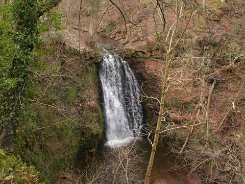
Falling Foss was audible from the car park, noisy somewhere down in the valley, the falling water mixed with the sounds of half-term children.
We had the neighbour’s dog, a spaniel named Merlot, and off we zoomed, into the woods, down terraced paths on steep banks, the sound increasing.
Falling Foss doesn’t disappoint, May Beck takes a clean, long, drop to a pool, but it would have been better with more volume, and the tea garden at the solitary house called Midge Hall was seasonally shut.
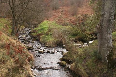
We moved on up, along May Beck, in pretty woods of oak and ash and holly. Soon there will be bright flowers but for now evergreen sedge knit together the banks and epiphytic ferns droop low from branches over the water. Merlot had a cooling paddle.
After a while we reached another little car park. We kept with May Beck, another nice mile with small waterfalls, up into the conifers of Newton House Plantation.
The Forestry Commission provide fair freedom for dogs, that’s why we were here. The commission don’t fuss, for them the protection of small furry animals, pheasants and deer etc is not paramount, though, rabbits forbid, I’m not suggesting this is the land red in tooth and chainsaw.
We reached our big forest track which, just at this junction, crosses the very thin straight line of the Cleveland Dyke, named here the Whinstone Ridge, that angles from Teesside to Scotland.
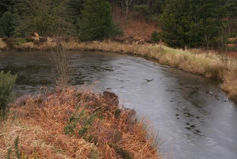
Whinstone is a hard volcanic stone once used for roads and cobbles, and here there is a pond in an abandoned quarry. Merlot passed on this, it was iced over, but at the next pond, with rushes and pussy willows, he had another hot, thirsty paddle.
The forest track makes for speed walking for a couple of miles, and it’s not all tall conifers, much is felled and replanted between the stumps.
After a long straight drag, we caught a view to the sea cliffs at Ravenscar, a view that will vanish in a few years as the trees grow. And note, there’s felling currently in the top corner, the western end of our route, by UPM Tilhill, Britain’s biggest operator, so you can only do this walk on weekends and public holidays until March 31.
By the way, around here on the moor, during the Second World War, lights were laid out to try to trick the Luftwaffe into bombing the heather rather than Teesside.
We turned, and soon could see to pastures and farms.
Something, perhaps someone, lurking in a patch of wild rhododendron, spooked the dog, and the silent Merlot barked for half a minute. Talking of which, it hadn’t been a muddy day for us, but for him it was an obligatory, cleansing swim back at Falling Foss.
Directions
When in doubt look at the map. Check your position at each point. Keep straight on unless otherwise directed.
View a map of the Foss Falls country walk>>
1. From car park entrance cross road end to gap in wall and path down through wood, 300 yards, left (three-way fingerpost, Falling Foss).
2. At waterfall and Midge Hall, footbridge, 50 yards on track, masonry bridge on left over May Beck and immediately right. Keep to nearest good path to May Beck. Path pulls 100 yards from beck then curves back to footbridge over side stream, then left. Path climbs. New gate.
3. Right over bridge over May Beck at May Beck car park, main track uphill.
4. On right hand bend, path on left (waymark post), downhill, steps, footbridge and fork right, snickelgate/fieldgate. Path by May Beck uphill. Ignore a lesser route forking right downhill.
5. Turn right (waymark post), 100 yards then right to main forest track, and immediately pass old quarry pond.
6. Right at junction. Keep to main track. Pass pond to right.
7. Good forest track on left at small rectangular concrete pond. Further on track was muddy due to felling operations.
8. Grass track on right, becomes path downhill in young plantation.
9. Stone gate post in ruined wall, path swings right by trees, 200 yards then swings left through trees.
10. At plain old post in rhododendrons before lake, ford on right, five yards, fieldgate into field, uphill by wall, track between fence and old hedge.
11. Gate/fieldgate into farmyard keeping farm buildings to left and metal fieldgate out of yard. Track by wood, downhill, gap/fieldgate, into wood.
12. Midge Hall, Falling Foss, over masonry bridge and left to good track ‘road’ up to car park.
Fact file
Distance: Six miles.
General location: North York Moors.
Start: Falling Foss.
Right of way: Public paths and Forestry Commission open access.
Dogs: Legal.
Date walked: February 2012.
Road route: Various, but best to avoid Littlebeck.
Car parking: Free car park.
Lavatories: None.
Refreshments: Falling Foss Tea Garden, seasonal.
Tourist and public transport information: Whitby TIC 01723 383636.
Map: Drawn from OS Explorer OL27 North York Moors eastern.
Terrain: Stream and forest.
Difficulty: Moderate.
Please observe the Country Code and park sensibly. While every effort is made to provide accurate information, walkers set out at their own risk.


Comments: Our rules
We want our comments to be a lively and valuable part of our community - a place where readers can debate and engage with the most important local issues. The ability to comment on our stories is a privilege, not a right, however, and that privilege may be withdrawn if it is abused or misused.
Please report any comments that break our rules.
Read the rules hereComments are closed on this article