
GEORGE WILKINSON makes a break for Boltby Forest.
Sneck Yate means a gate with a latch. That’s gone and instead there’s a little car park at a quiet junction.
This is the point where the very ancient Hambleton Road, a track from Osmotherley, becomes the Cleveland Road that is now metalled highway for the few miles it runs to the National Park Visitor Centre at Sutton Bank.
We took neither, instead popped down Sneck Yate Bank for misty views towards Thirsk before we dived into a spur of Boltby Forest on the Cleveland Way, and through some scrub. Our first mile was bright with red, yellow, whites, purple and the blue of the bugle.
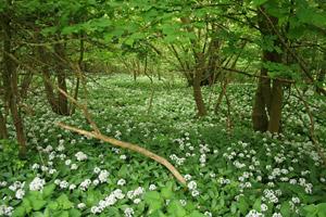
Rain brought a tang of garlic.
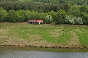
Tracks wiggled down to Low Paradise, where there’s a house and a farm. They are a good half mile from something we avoided, named Hell Hole.
Low Paradise was delightful for a damp wood threaded by tiny crystal spring streams and carpeted in mint, a plant that hybridizes readily. However the place was not quite a paradise for the walker because of an awkward fastened-up gate.
Thanks to the woman on the quad bike who confirmed our route.
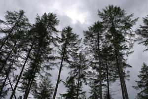
We skirted Hagworm Plantation, as named of old, the worms being adders, and reached the wide smooth tracks of the Forestry Commission’s Boltby Forest, the main block of conifers.
Thrice deer, in pairs or single, bounded across the track. Boltby Reservoir is about the size of a football pitch or two. By the middle of the forest, the sky was down to about one per cent blue, the rest being darkening grey and we expected a soaking. None came.
The tracks split, and eventually there was steep one out where a runner caught us up and then had to halt to encourage her slow dog.
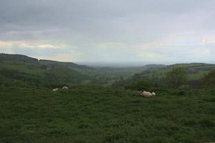
For the rest, we turned on to the nice path and track of the Hambleton Road and the contrast of the airy flat for nearly two miles, lovely for the wide views over the heather to the moors.
Directions
When in doubt look at the map. Check your position at each point. Keep straight on unless otherwise directed.
View a map of the Boltby Forest country walk>>
1 From car park right to road, 300 yards, track/path on right (Boltby Forest). Fieldgate into scrub (waymark).
2 Fieldgate and left to metalled drive, leaving the Cleveland Way, down curving left past bungalow, 200 yards, right (public footpath fingerpost) to metalled drive.
3 At Low Paradise fieldgate into garden (‘private’ and ‘footpath only’ signs), pass in front of house, gravel, stile in hedge (waymark after), 20 yards. Stile on left (waymark), cross one stream, pass head of gully, briefly follow stream to your left, on open area cross stream, 100 yards.
4 Fieldgate, was tied up and awkward, the authorities say it will be rehung but perhaps not immediately, so try if you like a rickety stile in fence 100 yards down to right or retreat to Low Paradise and take the route option (waymark) from the edge of garden as on map, we didn’t do the latter. From said tied-up or re-hung fieldgate, cross field to nearest power pole, next pole (waymark), angle one o’clock downhill, through old boundary hedge, step ditch, hurdlegate near fieldgate, stream, 100 yards.
5 Fieldgate and right to wide forest track, 2/3 mile, track on right with safety rails to view reservoir, return to forest track, 1/3 mile 6 Ignore junction left uphill, 1/3 mile.
7 Right at ‘Y’ junction where felled area ahead, 400 yards, left at ‘T’ junction and uphill with gully/stream to left.
8 Right at ‘T’ junction, 100 yards, cross track, uphill.
9 At top, left 25 yards, right to lesser track.
10 Right to nice path near edge of wood, the Hambleton Road, after trees becomes walled track. Don’t take the right fork to the Cleveland Way.
Fact file
Distance: Five miles.
General Location: North York Moors.
Start: Sneck Yate.
Right of Way: Public and Forestry Commission Open Access.
Dogs: Legal.
Date walked: May 2011.
Road Route: Via North York Moors Sutton Bank Visitor Centre.
Car Parking: Car park, signs. Grid Ref SE509877.
Lavatories: Visitor Centre.
Refreshments: Visitor Centre.
Tourist & Public Transport Information: Visitor Centre 01845 597426.
Map: Drawn from OS Explorer OL26 North York Moors western.
Terrain: Escarpment.
Difficulty: Moderate.
Please observe the Country Code and park sensibly. While every effort is made to provide accurate information, walkers set out at their own risk.


Comments: Our rules
We want our comments to be a lively and valuable part of our community - a place where readers can debate and engage with the most important local issues. The ability to comment on our stories is a privilege, not a right, however, and that privilege may be withdrawn if it is abused or misused.
Please report any comments that break our rules.
Read the rules hereComments are closed on this article