


Anya’s Wood is a memorial to a North York Moors National Park’s officer. It grows on Hazel Heads and adjacent is a large grass car park.
There had been a rough night and it showed, leafy twigs lay torn from the oaks; Blow Gill blasted over a waterfall and hardly anything was motoring on the tight curves of the back lane.
And after a mile we left the road and passed Scotland Farm, this is Snilesworth territory.
The route picked up a small valley, started to shadow it, taking a mile of a prehistoric ridgeway track up over the moor.
The grouse kept low and the wind sped over heather which held a last lingering purple from a few per cent of its flowers. Perhaps the brightest colour was on a violet ground beetle.
The track vanished into distance, it connects remnants, and there are visual clues to ancient field systems. We turned and tightened on our valley, a shallow plain crease where Parci Gill runs past a domino of small fields. But, notably and obviously, we headed to the Bilsdale Transmitting Station. And then we veered past it, through Meggy Mire to Miley Howe, the top spot, the head of Parci Gill, at 1,300 feet.
Then we closed on the mast, 1,030-feet high and pencil thin, close enough to admire the engineering of its guy-wire anchors. It was erected by the BBC in 1971, now the bottom of its column is studded with discs.
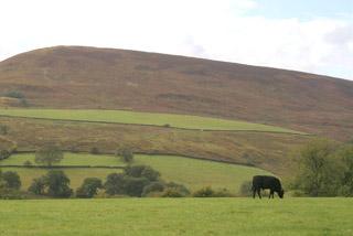
Turning south left it behind. The flash of a fast jet hammered a valley below us. From Sour Milk Hill we saw the grey rain sweep through the green Hawnby Hills and we watched the water flow.
Most of the day’s tracks had recently had their side ditches cleaned out. Plastic pipes lay on the heather, ready for installation. Moorland drainage is a hot chestnut; the interests of the grouse are opposed to the interests of those living and working by the lowland rivers.
Every time I come to Snilesworth I check the brilliant book of that name by Bill Cowley. He writes that 7,000 flints were found at Parci Gill dating from 7,000 BC and that it has been a ‘clear political boundary since at least the 12th century’. Cowley reads the landscape as continuity from the Bronze Age till the present day, particularly he analyses the recycled stone of walls and settlements.
You can see this change happening today, on this walk. Take the isolated farm ruins up Parci Gill that in 1851 was occupied by Ann Chapman, a widow, her five children and a farm labourer, but has been empty since 1891.
Similarly, after crossing Hawnby Moor, we entered the woods and found imprisoned by a conifer plantation some ‘Wildwood’ oaks and the spooky hushed ruins of High Hazel Heads Farm, empty since 1946.
Large red ants were quite active on their huge heaps and, in the woods, bulged with many sorts of fungus, in many colours, but for the walker not a yellow waymark arrow.
Nevertheless, rather surprising ourselves, we emerged on target at the car park.
Fact file
Distance: Seven miles.
General location: North York Moors.
Start: Anya’s Wood.
Right of way: Public and Open Access.
Dogs: Illegal.
Date walked: September 2010.
Road route: Via Hawnby or Osmotherley.
Car parking: Large grass car park area, Hazel Heads info board.
Lavatories: None.
Refreshments: Hawnby.
Tourist and public transport info: Helmsley TIC 01439 770173.
Map: Drawn from OS OL26 North York Moors western.
Terrain: Moor.
Difficulty: Moderate if fine.
Please observe the Country Code and park sensibly. While every effort is made to provide accurate information, walkers set out at their own risk.
Please observe the Country Code and park sensibly. While every effort is made to provide accurate information, walkers set out at their own risk.
Directions
When in doubt look at the map. Check your position at each point.
Keep straight on unless otherwise directed.
1 From car park (Hazel Heads info board) left to road. Cattlegrid/gate.
2 Metaled farm drive on right (footpath sign, Scotland Farm), gates/cattlegrid, 300 yards, straight on at bend to track, 100 yards, stile/fieldgate by wood (waymark).
3 Tall slim cairn on left, 100 yards, grass and heather track on right before grouse butts, downhill. Left-hand bend, gently uphill, ignore right fork downhill.
4 Right at T-junction with quarry about 100 yards to your right (redundant metal ‘no entry’ sign).
5 Switchback to first track on right, was heather and grass (wooden post and yellow dot on stone). Track turns sharp left.
6 Switch back to good track on right 100 yards before mast. 7 At fields, ignore track on left and continue with fields to left. Gate in dip (waymark)/fieldgate on track.
8 At trees and at fieldgate on left into ruins (waymarked), turn right to track across moor, becomes path, cairn, angles downhill.
9 Ignore right turn steep downhill (waymark post), continue contouring, path sometimes fades, then becomes sunken path and descends to wood about 50 yards above ruined barn.
10 Fieldgate into wood (yellow dots), straight on grassy path through ruins.
11 At T-junction, right for 50 yards, track on right for 20 yards, step over fallen tree, ten yards, left downhill at junction on grassy path.
Right 20 yards, left. At new metal gates, take a right to road and car park.


Comments: Our rules
We want our comments to be a lively and valuable part of our community - a place where readers can debate and engage with the most important local issues. The ability to comment on our stories is a privilege, not a right, however, and that privilege may be withdrawn if it is abused or misused.
Please report any comments that break our rules.
Read the rules hereComments are closed on this article