
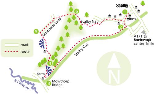
Victoria Ellis takes the reins this week as she treads the landscape of Scalby, near Scarborough.
Scalby is a village that is nowadays attached to Scarborough as its northern point, a mile from the town centre, the same from the sea and with interesting countryside inland. George Wilkinson, recovering from flu, didn't feel like walking, though this route wouldn't have taxed him much.
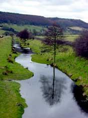
Within minutes I had joined the other walkers and the dog walkers on the banks of the Scalby Cut. This is a five-mile trench that was made in 1804 to take surplus water from the River Derwent and put it out to sea rather than having it flow many miles back inland and through Malton in its ice-age perversity. A trench, be it 200 years old, is rather unfair, it's nice to walk along on the footpaths that run on the regular high grassy banks each side. If you have a walking partner and should you have had a row you could take the separate in sight and shouting distance paths. But surely the landscape would mitigate any angst as the cut is set in a nice valley, open mostly, wooded on higher ground. There wasn't much water from the Derwent but it looked clear. There are a few small weirs and a series of level posts that march up the banks to remind of the flooding potential.
It was a warm, quick couple of miles along the cut to Mowthorp Bridge where there's a farm. As soon as I started to climb I caught the wind off the sea. And also caught up with about 50 walkers out with Hull Country Holidays Association, and I got chatting to one who told me members of the Ramblers' Association were going to start checking the paths on every square of the maps for England and Wales. And yes they are. The 180,000 one kilometre squares are going to be checked by the 140,000 association members and others.
Somewhere near Scarborough there is reputed to be the emptiest kilometre map square in England, but it's not here, there are lots of paths, notably in the adjacent Forge Valley and Raincliffe woods, which will soon be bursting with spring.
As for this route, I continued climbing, a total of 400ft, some on a green sunken path, some through woods of beech and larch and on the tops I trod a bit of dead-end back lane. There are super views to the sea that was by now four miles away, Scarborough Castle stands out. There was snow on northern fields and inland to the moors. There is a tower, a mystery to me, perhaps a sighting tower for drainage works?
Then I came down Scalby Nab, found another green sunken path and rejoined the throngs of horse riders, runners, cyclist and walkers out in the Sunday sunshine.
Directions
When in doubt look at the map. Check your position at each point. Keep straight on unless otherwise directed.
From St Laurence's Church 100 yards to little green with stream, left to road (signed Scarborough) and pavement.
Stile/fieldgate on right before bridge (signed). After a couple of miles track rises gently about 50 yards away from water.
At wall corner near farmyard gates (waymark post), turn right uphill on grassy track by old hedge trees. Stile/fieldgate near wood, 20 yards, left to path between fields up to wood (waymark post).
Fieldgate to sunken path up through wood, field-edge path with hedge to right, skirt house/garden via path on right (waymark), join drive.
Right to dead-end road. At left-hand bend, track on right 50 yards to fieldgate/stone stile (signed), grassy track, fieldgate on right in corner and left to field-edge path.
Stile (waymark), 100 yards, right at fingerpost across grass for 50 yards to stile (waymark), path angles down hillside then between two houses and left to private road. Right to road, verge then pavement, into Scalby.
Fact file
Distance: Six miles.
Time: Three hours.
General Location: Near Scarborough.
Start: Scalby.
Right of Way: Public.
Map: Drawn from OS Explorer OL27 North York Moors western area.
Dogs: Legal.
Date walked: Sunday, March 19, 2006.
Road Route: A171 north out of Scarborough, Scalby village signed.
Car Parking: Roadside.
Lavatories: None.
Refreshments: Nags Head and Plough Inn at Scalby.
Tourist & Public Transport Information: Scarborough TIC 01723 373333.
Terrain: Valley and valley side.
Points of interest: To partake in the Ramblers survey: www.useyourpaths.info Difficulty: Moderate.
Please observe the Country Code and park sensibly. While every effort is made to provide accurate information, walkers set out at their own risk.


Comments: Our rules
We want our comments to be a lively and valuable part of our community - a place where readers can debate and engage with the most important local issues. The ability to comment on our stories is a privilege, not a right, however, and that privilege may be withdrawn if it is abused or misused.
Please report any comments that break our rules.
Read the rules hereComments are closed on this article