
George Wilkinson notices the signs of spring during a walk at Bolton Abbey.
Bolton Abbey was springtime busy with walkers, cyclists, and general wanderers. The River Wharfe, charged with Dales rain, runs past the old abbey and draws the crowds, but this is not countryside-lite, the sunlight caught the moors and we climbed away to the quietness hitting the heather after half an hour, after Back O' Th' Hill Farm and at about 750 feet.
A large raptor flew high, from a photo I took I can say with confidence it was a red kite, they have a distinctive forked tail, a five and a half foot wingspan and apparently have taken a fancy to this estate which is only 20 miles as the kite flies from their original release point at Harewood House near Leeds.
Curlews hung in the wind rippling out their songs until a pair of predators spooked them into aerobatics. By now there were cracking views down into Wharfedale, the throngs there diminished to bright dots, and the shape of our valley was clear and also the reflective shape of our route which loops it at a high level, at over one thousand feet.
The lovely line of drystone wall separated the sheep pasture from the heather moor above and we moved through the heather easily because all the way round is a comfortable stone/ grass track, head up walking, super.
Apart from the birds there was a sad sign of spring in a doomed gob of frogspawn in a shallow puddle. And on the subject of signs there are a number of old and lichen encrusted fingerposts pointing to "Access Area" which is because this large expanse of moor has for more than 30 years been open access and well publicised, a success story that proves that walking and grouse shooting can happily co-exist, whether kites and gamekeepers can co-exist is to be seen.
There's the valley beck to cross but that was only one step and there's a waterfall by the ford, and then a little further on a grotto-like shelter built into rock, a sandwich stop with an overview of the day's territory with distant wind turbines at Chelker Reservoir, I like these both for reasons green and aesthetic, after all we all love ye-olde windmills and the modern versions are much more elegant.
The track ran down another mile, and the Abbey was visible for about that distance, and then the last descent was through Bolton Park with old oaks and new lambs, to the Wharfe again.
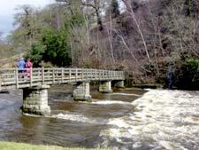
Perfectly placed, just across a bridge, is the Pavilion and here were hundreds of people, drinking, feeding and people watching, including two girls walking ferrets. Rain shifted us on, there's another mile to do, up and down the garlic woods above the river till the big empty lancet windows of the abbey were there again, a splendid walk.
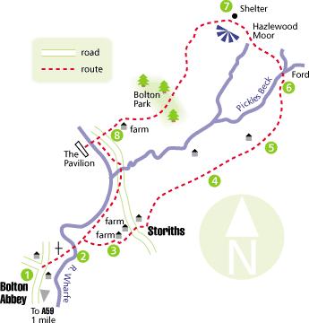
Directions
When in doubt look at the map. Check your position at each point. Keep straight on unless otherwise directed.
1. From car park cross road to gate in hole in wall, steps, path downhill.
2. Bridge, 25 yards, fork right uphill on steps to path, 100 yards, path on right (fingerpost), 50 yards, walled path on left uphill (fingerpost "Storiths").
3. Concrete track through farmyard and left to farm track. Cross road at junction, track to right of house, swings left at wall corner and left to track and Access Info board, 100 yards, fork right before house to cattlegrid (fingerpost "Barden Fell"), 200 yards, fork right (fingerpost "Access Area").
4. Fork right where private sign ahead, house a field away and left fork is downhill (fingerpost "Access Area"). Ignore path on right on bend.
5. Ignore right fork uphill 20 yards after fingerpost where house a field away. Track heads round head of valley.
6. Ford at sheepfold, stay on track.
7. Stone shelter 50 yards to right of track, 50 yards, left to track downhill, fieldgate to track through grassland, fieldgate, by edge of farmyard, road. Bridge to Pavilion, back over bridge.
8. Immediately gate on right to riverside path, road, ford, 50 yards, path on right, bench, ten yards, right fork downhill, gate to path across field, footbridge and outward route.
Fact file
Distance: Six and a half miles.
Time: Four hours.
General location: The Dales.
Start: Bolton Abbey.
Right of way: Public, permissive paths and open access.
Dogs: Not legal.
Map: Drawn from OS Explorer OL2 Yorkshire Dales southern and western areas, or OL 297 Lower Wharfedale.
Date walked: Sunday, March 26, 2006.
Road Route: From York: via Harrogate or Otley.
Car Parking: First car park, on left at Bolton Abbey village, fee.
Lavatories: At car park and Pavilion.
Refreshments: Kiosk at car park, nearby teashop. Restaurant and tea inside and outside at Pavilion. The Devonshire Arms.
Tourist & Public Transport Information: Tel: 01756 718009, www.boltonabbey.com Terrain: Mainly moorland.
Points of interest: Wheelchair route along river.
Difficulty: Moderate in good weather.
Please observe the Country Code and park sensibly. While every effort is made to provide accurate information, walkers set out at their own risk.


Comments: Our rules
We want our comments to be a lively and valuable part of our community - a place where readers can debate and engage with the most important local issues. The ability to comment on our stories is a privilege, not a right, however, and that privilege may be withdrawn if it is abused or misused.
Please report any comments that break our rules.
Read the rules hereComments are closed on this article