
Wensleydale walking can be some of the best, but the Dales weather was April 1st showers so we stopped at Leyburn for a coffee and decision time - a low level stroll or possibly a fool's foray to the heights.
There were only a few dabs of cloud on the higher ground and the riverside pastures were likely to be sodden so it was onwards to the village of Thornton Rust for the up and up.
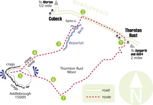
In the little car park a cheerful farmer with a sprig of flowers in his pick-up grill laughed and said 'showers all day', even mentioned the S word. Undeterred we filled our sack with waterproofs and did the leg loosening mile along a quiet loop-road to a notice that showed a National Trust permissive path up to the summit of Addlebrough. We've walked around this tabletop hill for decades, and the CROW Act means that one can explore the top.
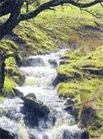
At first the pasture was benign. Then the slope sharpened and the route paralleled East Beck which is pretty and fascinating, a limestone stream with cascades, a sink hole, and a resurgence, it disappears under the ground and pops back up again, it gushes through ducts in the drystone walls and there's a good waterfall.
Spring comes late in the high deep Dales; I saw one flower, a celandine. Birds had arrived and lapwings flew strong in the breeze. The sun shone, Addlebrough stood solid, and we thought we'd made the right decision on our route. Until the crossing of a wide flat grass terrace when the wind hit, bringing teeth-cracking hail. Bodies wrapped in Gore-Tex, heads down, the aforementioned were gritted for half-an-hour of grind. Then it stopped, the landscape lit bright again and just in time for the last climb, a steep handful of contours.
In prehistoric days one would have felt safe, if not warm, up here, the acreage of the top is at an altitude of 1,500ft and is surrounded by steep slopes, with crags on most sides.
It was very windy; we snatched a view from the western edge down to Semer Water in Raydale, a rare natural Yorkshire lake. There's a cairn with cup marked rocks but we missed that, hurrying to huddle behind a wall to sup tea. To the east runs Wensleydale and in the clear air the North York Moors were visible 40 miles away.
Our descent was steep at first then more gentle over lovely pale gold grasslands. There are lots of little becks and a zone where there was one or two per cent heather cover. The River Ure curved through Wensleydale with its adjacent fields mirrored with water. The return was quick, only tricky at a flooded ford just above Thornton Rust. National Trust waymarking was useful, but in poor visibility Addlebrough wouldn't have been nice.
Directions
When in doubt look at the map. Check your position at each point. Keep straight on unless otherwise directed.
Left from parking area to road.
Ladderstile on left (fingerpost Addlebrough), ladderstile (arrow), uphill by wall to right, ladderstile on right (arrow) and left uphill by stream, stile (arrow), path, skirt area of fenced young trees and return to streamside, gateway.
Ladderstile (arrow) and keep gently uphill on path about 25 yards away from wall as it curves round, stile, stile, ignore a path forking right after a sleeper footbridge.
Just past a wall coming down hillside left to ladderstile (arrow), duckboards, steep climb.
On top, west to view Semer Water, watch for steep drops, retrace steps. 200 yards to cemented cairn, immediately ladderstile (GR 947881), faint path at 1 o'clock ie c120 degrees for 200 yards over hillock (white top post on ground), path steep down hillside towards nearest field corner on plateau.
At handful of rocks and waymarked post turn right, 50 yards, then path angles across wall corner and uphill angling away from wall, not the grassy track downhill to left.
Ladderstile, 10 o'clock on path for 50 yards, left to path/track at fingerpost, 50 yards, ladderstile/fieldgate, track for 2/3 mile, fieldgate, track crosses field, right at wall to track (fingerpost), ford and fieldgate, stony track back to village.
Fact file
Distance: Five miles.
Time: Three hours.
General location: Yorkshire Dales.
Start: Thornton Rust.
Right of way: Public and permissive paths and access land.
Map: Drawn from OS Explorer OL30 Yorkshire Dales northern and central areas.
Dogs: Not suitable.
Date walked: Saturday, April 1, 2006.
Road route: A684 via Leyburn to Aysgarth, fork left, signed.
Car parking: Small car park, signed, roadside.
Lavatories: None.
Refreshments: Aysgarth.
Tourist & public transport information: National Parks, Aysgarth 01969 662901.
Terrain: Hill.
Points of interest: Stoney Raise Cairn, half-a-mile off route.
Difficulty: 700ft climb.
Please observe the Country Code and park sensibly. While every effort is made to provide accurate information, walkers set out at their own risk.


Comments: Our rules
We want our comments to be a lively and valuable part of our community - a place where readers can debate and engage with the most important local issues. The ability to comment on our stories is a privilege, not a right, however, and that privilege may be withdrawn if it is abused or misused.
Please report any comments that break our rules.
Read the rules hereComments are closed on this article