
George Wilkinson takes a step back in time to Heartbeat country.
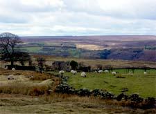
GOATHLAND is, of course, the heart of Heartbeat country. Among its many attractions it has a station on the North Yorkshire Moors Railway. Here a photographer had his tripod set, but it was too cold to wait with him for the steam train, so we crossed the tracks from 60s nostalgia to twenty-first century open access moorland and headed north. It soon dawned that we were not tramping just any normal Landrover route, there being a precision of gradient, a couple of metal spikes, a rotting sleeper. The easy walking made for rapid progress but not to any great altitude, Goathland Moor is not one of the highest, but up enough to see plenty of the moors - the heather, the grasses, withered bracken and the curlews and lapwings.
Two miles took no time and, with the track, we soon reached Whinstone Ridge. This ridge shows on geological maps as a ruler straight line angling across the North York Moors. But it's a ridge reduced, because it was quarried out for the Whinstone, the only rock hereabouts hard enough for early road surfacing, one of its last uses was for World War II aerodromes. The ridge is a deep V shaped quarry, really quite dramatic.
We walked along its length a while, taking in the views that to the west hold a handful of Esk Dale villages.
This spring has been awful so far, we've often worn more clothing than on midwinter walks and this day was no exception, soon there was hail turned to rain to diminish the pleasure. We sped through ancient field systems of fallen down walls, barely glanced at an old cottage neatly fixed up, averted gaze from one that's a muddle of shapes, took whichever path led downhill, heard the urgent chuffing of a steam train, saw only its white puffs and found ourselves cowering on a bench under a holly tree right at the edge of Newton Dale.
Below the bench the rail line runs alongside the waters of Eller Beck and normally here would be a very good place to sit and wait for sight of the train, but the shelter of Beck Hole seemed a much better bet. A quarter of a mile and we were there. Arthur Mee described it in 1941 as "a tiny hamlet as lovely as its situation" and with "rare flowers". Nowadays it's better known for its tiny pub. The two bars were packed, the dozen or so walkers faced with drinking in the rain or steaming together tight as penguins. They seemed a little disconcerted that, having set out for open spaces, they were then to be denied any modicum of personal space, but at least were well armoured by their layers of clothing.
All that was left was the pleasant incline, once a horse-drawn railway, back up to Goathland through woods about to burst with the delayed delights of spring.
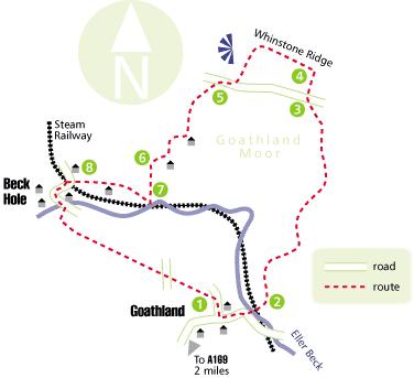
Directions:
When in doubt look at the map. Check your position at each point. Keep straight on unless otherwise directed.
1. From car park to main road, left, downhill, bridge, station, gate, railway lines, gate, steps on left uphill (fingerpost), then path, ignore right fork, 50 yards.
2. Left to grassy track.
3. Fingerpost and cross road, through cleared area, grass track between mounds, cross track.
4. Left at Whinstone ridge. Left at fence/walls to track downhill, fork right 50 yards to road, right to road.
5. Track on left beside walled fields to left. Ignore left fork 50 yards before house, right to track by this house, track, pass house, path by wall.
6. At wall corner, fork right downhill, pass to right of it, but angling away from old walled enclosure size of tennis court, 100 yards, path downhill in gully with little stream on right.
7. At green bench under holly trees near railway bridge, right to path beside fields to left, pass house, join track.
8. Left at house to farm road, left to road and bridge, through village, track on right after pub (fingerpost, fieldgate), fieldgate and left to path/track uphill (fingerpost). Gate, cross road, gate, wide grass strip, snicklegate and right to road, car park 100 yards.
Fact file:
Distance: Five miles.
Time: Three hours.
General location: North York Moors.
Start: Goathland.
Right of way: Public and Open Access, remember to check for Open Access Restrictions on redesigned website www.countrysideaccess.gov.uk Date walked: Saturday, April 8, 2006.
Road route: From A169 signed and a few miles.
Car parking: Car park £1.50, little roadside.
Lavatories: Goathland car park.
Refreshments: Goathland and Beck Hole.
Tourist & public transport information: Goathland info centre.
Terrain: Mostly moor.
Points of interest: Nearby waterfalls of note.
Difficulty: Quite easy.
Please observe the Country Code and park sensibly. While every effort is made to provide accurate information, walkers set out at their own risk.


Comments: Our rules
We want our comments to be a lively and valuable part of our community - a place where readers can debate and engage with the most important local issues. The ability to comment on our stories is a privilege, not a right, however, and that privilege may be withdrawn if it is abused or misused.
Please report any comments that break our rules.
Read the rules hereComments are closed on this article