
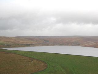
Grimwith Reservoir was bleak, full of grey Yorkshire Water’s water, or more exactly Yorkshire Dales National Park water that had run off the moors between Grassington and Pateley Bridge, from sunny-sounding spots such as Hard Hill, Black Crag and Wig Stones Swamp.
We sat there looking at the reservoir through the windscreen wipers, watching it disappear in the squalls and then scuttled to the loos, because there it was easier to pull on the three warm layers topped by waterproofs than contort in the car. After a comfort cake, it was sally forth.
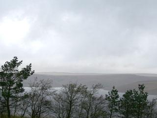
For a while the interest was behind, the changing angles on the dam; then there were shafts of light through the vapours up front; otherwise the Wharfedale hills were just a darker shade of sky.
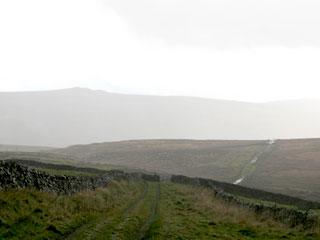
Luckily we had a track, a firm surface, one of those ‘green lanes’ only recently labelled public rights of way and this went straight and south so there was little need to look at the map or fiddle with anything. The rain hardened to hail; a sodden sheep fold was the only shelter.
Further south is the valley village Appletreewick, which has a pub, but we would have been in no fit state and would have contaminated the place. Anyway, it seemed better to stay on the higher ground of Appletreewick Pasture, which sounds nice, but there weren’t many trees; there were boggy bits.
A tup, a ram, was painted red underneath, enormous tackle and all, and a shepherd toured his various flocks on a quad bike and kindly inquired if we were lost. But we weren’t, it was simple to keep above Barben Beck which changes name at Dibbles Bridge to the River Dibb and unusually it’s a river first then down-river, a beck.
Head down into the elements one tends to mentally wander and wonder. You might notice from the map that the route passes something called Hell Hole, and indeed, there being limestone around, there are shafts and such, so wandering might be best avoided.
As for wondering – have just seen a programme about the moon landings and the emphasis on the ‘right stuff’ the astronauts had, their ability to be cool whatever, no panic.
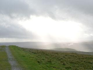
Hopefully, panic isn’t that frequent on my walks, but I think that the right stuff for a winter walker might include not moaning and moaning about the weather, a notion more pertinent as we were out when they were flooded in Cumbria. But one can’t help it. The rain stopped.
As we got back to the less grim reservoir, any overwintering birds were not apparent, but the surrounds were busy with partridge and pheasants. Another thing was surprising, a close inspection of the valve tower showed the reservoir, Yorkshire Water’s biggest, not quite brimming.
Fact file
Distance: Five miles.
General location: Yorkshire Dales National Park.
Start: Grimwith Reservoir.
Right of way: Public and private road.
Dogs: Legal.
Date walked: November 2009.
Road route: Via Pateley Bridge.
Car parking: Reservoir.
Lavatories: Reservoir.
Refreshments: None.
Tourist and public transport information: Grassington TIC 01756 751690.
Map: OS Explorer 298.
Terrain: Upland pasture.
Difficulty: Quite easy.
Please observe the Country Code and park sensibly. While every effort is made to provide accurate information, walkers set out at their own risk.
Directions
When in doubt look at the map. Check your position at each point.
Keep straight on unless otherwise directed.
1. From car park, pass below toilet block, left to metalled drive, 200 yards passing house on right, track, fieldgate, track.
2. Fieldgate and cross main road, fieldgate/ladderstile to track.
3. Fieldgate/ladderstile to road, 150 yards, gate by fieldgates on right (fingerpost Hartlington) to track. Gate/fieldgates, ladderstile/fieldgate, ignore left fork to farm, 100 yards, fieldgate to walled track (fingerpost).
4. Fieldgate on right (fingerpost Dibbles Bridge) into field, grassy track near wall to your left, ladderstile, fieldgate (fingerpost), 100 yards, short walled track on left with bridge.
5. Gate/ladderstile after bridge, 50 yards by wall to your right (fingerpost) then straight across field on sometimes faint path, gently descending. As main path swings right, straight across the dip ahead and head for the walled fields.
6. Ladderstile about 200 yards to the west of a jutting wall corner, cross field, gateway, 11 o’clock for 50 yards, ladderstile by fallen bit of wall, downhill on track to fieldgate/squeezer.
7. Right to main road uphill. Yorkshire Water private road on left.


Comments: Our rules
We want our comments to be a lively and valuable part of our community - a place where readers can debate and engage with the most important local issues. The ability to comment on our stories is a privilege, not a right, however, and that privilege may be withdrawn if it is abused or misused.
Please report any comments that break our rules.
Read the rules here