
BROMPTON-BY-SAWDON was dull and cold, so I’m told by Victoria my navigator, certainly not the place for me suffering a particularly weakening version of man flu. By dull she meant the light, also complained of by her photographer for the day (thank you, Colin, for this).
But the darkness did make the ‘streak of blue’, the ‘flash of a kingfisher’ that more vivid and the walk doesn’t sound dull generally, and I am sorry to have missed it.
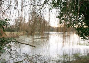
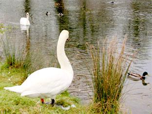
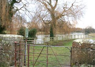
The village has notable water from the limestone on this southern fringe of the North York Moors. The millpond is the best part of an acre and a weir nicely centres the flow when it’s running low and there’s fishing. A pair of swans and some ducks swam around and preened.
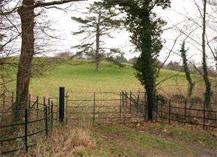
After the village, Victoria and Colin scooted across to the parkside of Wykeham Abbey where the 12th Viscount Downe lives. The huge Dawnay Estate belongs to his trust. You walk land owned by his family since 1656, revealed through the bare branches.
The park has a Ten Acre Plump and a Jubilee Plump; a plump being a clump of trees. The estate website chuckles with a tale of errant nuns. All the estate farmland is in the Countryside Stewardship Scheme, though there is not a generosity of footpaths and bridleways.
Gates and railings are of old iron. A no-entry sign bears a modernisation of the Downe coat of arms, the red lion still rampant, the word ‘Yorkshire’ added most reasonably.
Despite this the local hero is Sir George Caley, 1773-1857, the 6th baronet at Brompton Hall, but more importantly the “father of aerodynamics”, and a great engineer, most famously of flight, for which he identified the forces of “thrust, lift, drag and gravity”.
There is not much force needed for this one. After crossing the A170, with Scarborough down the road, our duo slipped through Ruston, where nest boxes are made, and then appreciated the tracks and flew north fast in the chill, Sleet Hill is a name.
Most of this route is on ‘green lanes’. Horses and cyclists can use them and this walk is apparently, repeat apparently, pushchair possible if you cut the first bit by the millpond.
As for horses, a few passed and a rider reported a “yellow parrot flying around the woods”, to which Colin replied that it would be “trying to keep warm”, an ornithological confidence repeated in his identifying a woodpecker by its drum roll.
And not forgetting cyclists because most of this walk would make a spin of homage to Sir George, who also invented the wire or tension-spoke wheel.
After a while of bleak and greening farmland, Victoria and Colin reached the village of Sawdon that is, despite the joining of names, a thinner place than Brompton. From here the report fades, the pub was heaving and they did not stop for comfort.
Church Lane let in chill from the sea and connected to Wood Gate that is open, straight track, a glide back, and, as a distraction from the view to the Wolds, the curiosity of a golf course set with lollipop leylandii.
Directions
When in doubt look at the map. Check your position at each point. Keep straight on unless otherwise directed.
1. From Church Lane, snickelgate opposite church (sign), by fence and pond, snickelgate by house and right to steps and path beside house. Left after house, bridge, cross road at junction, 100 yards across grass.
2. Cross road to track near beck and railings (footpath sign), through farmyard, track. Track ends and join fieldedge path (waymark), hedge gap, pass pond to your right, fieldedge path, bridge over beck and path switches to right of hedge.
3. Bridge and left to road. Cross main road and right on pavement, left into Ruston (sign).
4. First road on left (West Gate, dead-end sign). Becomes track, uphill. Track turns right for 100 yards then track on left, not ahead (Estate no entry sign).
5. Join road in Sawdon, uphill through village, first road on left (Chapel Lane sign).
6. Left downhill to track at four-way junction. After a mile and a half join road. Cross main road, right on pavement, first left (Hungate).
7. First right at Milford Cottage, No.38, and join railed path where road ends. Pass large pond to your left. Info board as you rejoin road, straight on for 50 yards, straight across at junction to Church Lane.
Fact file
Distance: Six miles.
General location: Near Scarborough.
Start: Brompton-by-Sawdon.
Right of way: Public.
Dogs: Legal.
Date walked: January 2009.
Road route: On A170.
Car parking: Roadside in village.
Lavatories: None.
Refreshments: Inns at Brompton and Sawdon.
Tourist and public transport information: Scarborough TIC 01723 373333.
Map: Drawn from OS Explorer OL27 North York Moors eastern area.
Terrain: Slope.
Points of interest: George Caley.
Difficulty: A snow walk.
Please observe the Country Code and park sensibly. While every effort is made to provide accurate information, walkers set out at their own risk.


Comments: Our rules
We want our comments to be a lively and valuable part of our community - a place where readers can debate and engage with the most important local issues. The ability to comment on our stories is a privilege, not a right, however, and that privilege may be withdrawn if it is abused or misused.
Please report any comments that break our rules.
Read the rules hereComments are closed on this article