
How the world has shrunk. Today, Huntington is very much a part of suburban York.
It is within spitting distance of Monks Cross, and strung out along a road - Haxby Road - that is pretty heavily built-up all the way to the outer ring road.
Not too long ago, however, this York neighbourhood was a distinct village - a small but relatively independent little community set well outside the York boundary.
An 1801 census shows Huntington to have had a population of 312. By 1851 this had grown to 416.
The chief industry in the village back then was farming. In 1850, over a distance of about a mile, there were 25 farms in the village, with the average farm size being 35 acres.
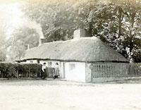
Our first photograph today gives a good sense of what the rural township of Huntington was like. The thatched cottages in our photo, which dates from the early 1900s, are thought to have been at the south west end of Main Street.
It is not difficult to imagine that for the villagers of Huntington in 1850, or even 1900, a journey into York would have been a fairly major undertaking.
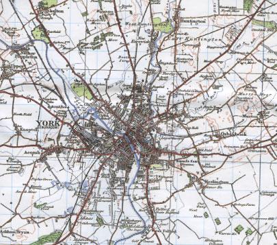
A splendid "past and present" map of York published by Cassini brings this home in a wonderfully vivid way. It is actually four maps in one. The first is a reproduction of the Ordnance Survey Old Series, first published in 1858.
The inner part of York, even back then, looks fairly familiar. But the city pretty much stops at the line of the city walls. Acomb, Heslington, Osbaldwick and the Poppletons are all separate villages, while Huntington is a good distance out of the city along the main north road. Strensall appears desperately remote.
Little has changed by 1903, when the OS Revised New Series map was published. Woodland around Skelton has disappeared and Holgate has grown a little, but has still not reached Acomb. That is true even in 1924, when the OS Popular Edition came out. The map is clearer, and easier to read, but the outlying villages of Heslington, Osbaldwick and Huntington are as outlying as they have always been.
Then comes the shock. The final map is present-day York. And the city, responding to the pressure of 20th century population growth, has grown and spread. Heslington, Acomb, Osbaldwick and Huntington have all been swallowed up - as has Haxby, now a satellite "new town". Even remote Strensall is connected to greater York by a thread of development. It is very familiar to the modern eye - but looking at these four maps together brings home how comparatively recent the expansion of York was.
* York Past And Present map, published by Cassini, is available from good bookshops priced £7.99. Past and present maps are also available for other areas. Visit www.cassinimaps.com
* Photos on this page are reproduced courtesy of the City of York Council's Imagine York website, www.imagineyork.co.uk


Comments: Our rules
We want our comments to be a lively and valuable part of our community - a place where readers can debate and engage with the most important local issues. The ability to comment on our stories is a privilege, not a right, however, and that privilege may be withdrawn if it is abused or misused.
Please report any comments that break our rules.
Read the rules hereComments are closed on this article