


LIKE most of York, Hungate has a long, rich history. The name means something like 'street of the hounds' in old Norse, and sure enough there is evidence that the Vikings did once build houses here, on the edge of the old Roman settlement. In medieval times there was a Carmelite monastery nearby - the monks (or more likely labourers they employed) may well have dug for clay in the Hungate area.
There was also once a church here called St John's on the Marsh - appropriately enough, given that it was on the edge of the King's Pool, a great marshy lake formed around the Foss on the eastern side of York (which is why there is no city wall there).
Whatever its past history, however, by Victorian times much of Hungate was a notorious slum.
Between 1801 and 1901, according to the Rowntree Society, an influx of immigrants saw the population of York treble. Seebohm Rowntree, in his 1901 book Poverty: A Study Of Town Life, identified Hungate as 'one of the main slum districts in York'. People lived cheek by jowl in densely packed housing with inadequate sanitation. Water-borne diseases were rife.
The York Corporation took advantage of the 1930 Housing Act to begin widespread slum clearances in the 1930s. Whole streets off Walmgate and in Hungate were pulled down and the residents moved to new council homes built outside the city centre, according to the History of York website.
The living conditions may have been appalling by modern standards. But, as our photos on these pages (which all come from Explore York's wonderful Imagine York photographic archive) reveal, there was clearly a strong sense of community among the people of Hungate before the clearances.
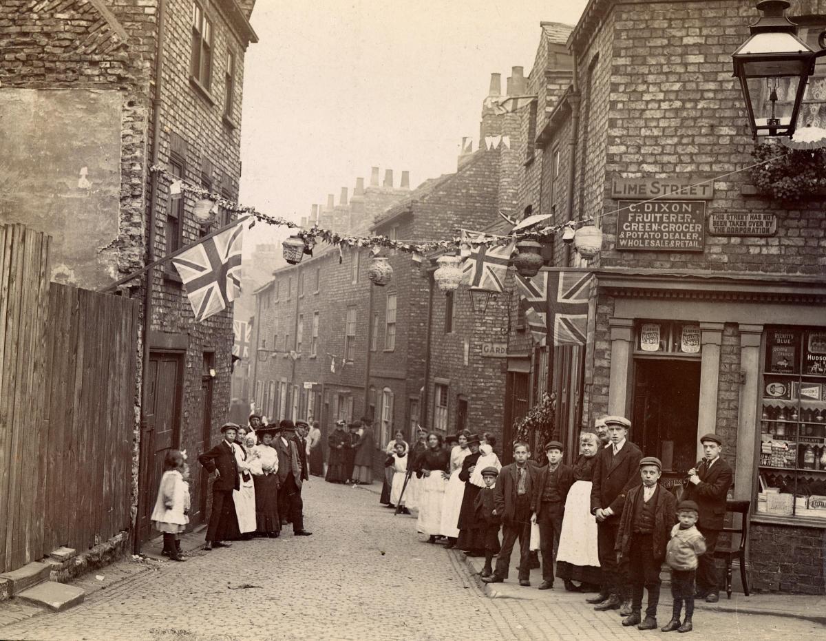
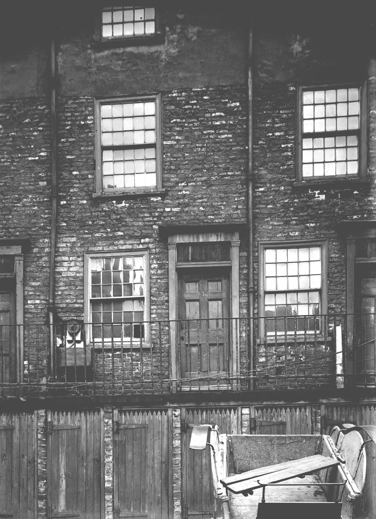
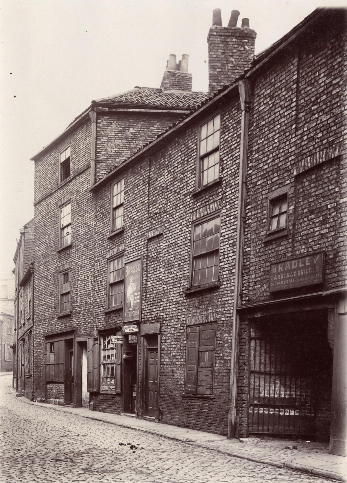
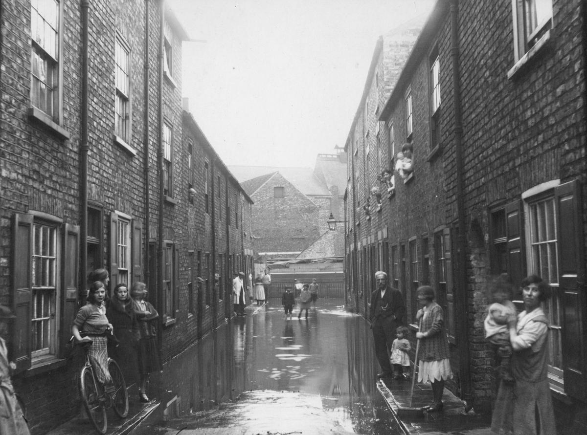
We have a photograph from 1907 showing a street party in Lime Street, Hungate, held to celebrate the jubilee of the York Adult Schools - schools set up by the Quakers to ensure those who had long ago left school or college could still continue to 'better themselves'; three photos from 1911 showing Bradley's Buildings, which seem to have been associated with the carriage builders Bradley and Co, based at 20 Hungate; and three more from the floods of February 28, 1933, showing how all the locals came out to pose for the cameras. What was that about water-borne diseases?
Here is a bit more detail about each of the photographs...
1. Residents of Lime Street in Hungate – many of whom will have been members of the York Adult Schools - who decorated their street in 1907 as part of the celebrations for the Adult Schools' jubilee
2. Bradley's Buildings in Hungate in 1911. The building was probably associated with Bradley and Co who were carriage builders at 20 Hungate. A water pump can clearly be seen in front of the house (to the left of the middle door) and the row of doors under the gallery were probably lavatories and coal stores
3. The entrance to Bradley's buildings on Hungate in July 1911
4. Bradley's Buildings in Hungate in 1911. The carriage to the bottom right of the frame is probably a remnant from the Bradley and Co carriage making business
5. A photograph taken by the York Health Department showing the level of floodwater on February 28, 1933, in Lower Wesley Place, Hungate. The photograph shows lots of people standing outside their homes, and others leaning out of the upper windows, whilst some children play in the water. One of the women has been using a brush to sweep the water away from her home
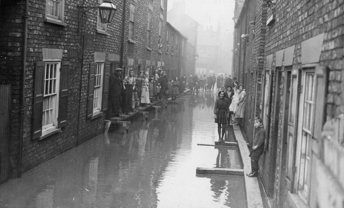
6. Flooding in Lower Wesley Place, Hungate, on February 28, 1933. There are large numbers of people standing on raised walkways at the end of the street - all of them appear to be looking directly at the camera. These houses were demolished in slum clearances in the late 1930s
7. People standing on raised walkways above floodwater in Wray's Yard, Hungate, on February 28, 1933.
Stephen Lewis
- All the photos on these pages, and thousands more, are held on Explore York’s Imagine York archive. You can browse it yourself at imagineyork.co.uk/


Comments: Our rules
We want our comments to be a lively and valuable part of our community - a place where readers can debate and engage with the most important local issues. The ability to comment on our stories is a privilege, not a right, however, and that privilege may be withdrawn if it is abused or misused.
Please report any comments that break our rules.
Read the rules hereLast Updated:
Report this comment Cancel