

The age-old problem of floodwater has returned to haunt York and the surrounding areas. RICHARD HARRIS reports on the battle to control the city's rising rivers
THE River Ouse has flooded for thousands of years and a settlement has existed at York since at least Celtic times.
Science and industry have changed the face of the world we live in and our knowledge of the natural world has never been greater.
But flooding can still bring the city to its knees, cost millions of pounds in repairs and destroy people's homes.
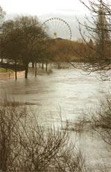
Thankfully, the floods experienced in recent days have been nowhere near as bad as those of 2000, when the River Ouse rose 5.4 metres above its normal level.
On Friday, the river peaked at 4.4 metres above the norm, but it was still enough to close the southbound lane of the A19 and flood out businesses along the river banks.
This was all caused by eight inches of rain falling 50 miles upstream in a week.
Colin Atkinson, flood incident management team leader at the Environment Agency (EA), said the problems stemmed from heavy rain in the Pennines. This ran into streams which entered the three main rivers which feed the Ouse - the Swale, Nidd and Ure.
In total, streams, becks and rivers over an area of land measuring 3,000 square metres - incorporating the North York Moors, Yorkshire Dales and Pennines - contribute water to the Ouse.
In the last seven days, 200mm (8in) has fallen in the hills compared to only 13mm (half-an-inch) in the York area. This is in contrast to the floods of 2000, when there were torrential downpours in the York area as well as in the Pennines.
But what can be done to solve the problem?
The agency is tasked with protecting the city and its people from this age-old adversary. There are various means it has at its disposal to do this.
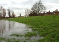
One of the best is Clifton Ings.
This natural flood plain can hold 2.3 million cubic metres of water, lowering the peak flood level in the city by 150mm.
In 1982, £1.25 million was spent installing sluices and fortifying the embankments to allow this amount of water to be stored.
The sluices can be opened to reduce the river depth. The problem recently has been the Ings filling up, meaning that the agency can no longer rely on them to soak up some of the floodwaters.
Other defences include the earthworks in Leeman Road. A flood bank was built there in 1980 after more than 200 houses were flooded in 1978.
The embankment was raised a few years later and the agency wants to strengthen and raise the embankments, to take account of the increased problems climate change is likely to bring.
However, as The Press reported on Saturday, Government cuts could jeopardise the proposed upgrade.
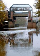
But one of the most visually impressive systems is the £3.3 million Foss Barrier. Work on this began in 1986.
If the volume of water in the Ouse dramatically and swiftly increases, the Foss could be forced back on itself leading to its banks being breached - this contributed to the floods of 1978 and 1982. But the 16.5 tonne barrier, which can be turned and lifted, helps to prevent this.
The problem of flooding on the A19 at Fulford could be solved if developers get the go-ahead to build hundreds of homes at nearby Germany Beck. Part of the development plan is a proposal to raise the height of the A19 above flood level.
A spokesman for the EA said York sits astride the confluence of the River Ouse and its tributary, the River Foss.
He said: "The interaction of the two rivers, with the significant amount of rainfall the catchment attracts, and the simultaneous melting of accumulated hill snow, makes the city particularly susceptible to flooding.
"York offers a unique challenge. Due to the complex geography of the area, the city is at risk from a variety of different sources. This has called for a co-ordinated and innovative approach to flood control."
At the mercy of the rivers
THE worst floods in 400 years affected York in 2000, but the city has long been at the mercy of its rivers.
The years 1995, 1991, 1982, 1978 and 1947 all saw severe floods, but the the people of York have had to cope with the rising waters for centuries.
Records show that in 1263, when King Henry III was on the throne, a river of water was swept through North Street up to the point where Ouse Bridge meets Bridge Street.
Then, in 1316, York Castle was surrounded by water, its earthworks suffering severe damage.
In 1564 - the year of William Shakespeare's birth - great chunks of thawing ice were trapped in a blockade which eventually smashed away part of Ouse Bridge.
There may be few certainties in life, but one can be sure that floodwater from York's rivers will continue to affect both the city and its citizens.


Comments: Our rules
We want our comments to be a lively and valuable part of our community - a place where readers can debate and engage with the most important local issues. The ability to comment on our stories is a privilege, not a right, however, and that privilege may be withdrawn if it is abused or misused.
Please report any comments that break our rules.
Read the rules hereComments are closed on this article