
GEORGE WILKINSON enjoys an afternoon walk at Middleham, treading where in the morning the horses gallop.
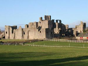
MIDDLEHAM’S racehorses clipped into town after their blast on the moor. The castle was shut, so only the crows and pigeons got the view from the battlements.
Those of us hugging the ground slid off through a narrow ginnel of flags and cobbles and the public loos. However, before you gallop off, I recommend you check Middleham’s pubs, because this is, of necessity, an afternoon walk.
Afternoon maybe, but the winter sun had the low slant, just right for showing off the sinister shapes of the castle and the rolling contours of grasslands.
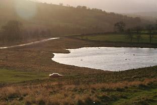
Children played football and my navigator exclaimed ‘penalty’, which it wasn’t. A mile to the north there were acres of standing water by the River Ure with flocks of gulls and others. A dusting of pigeon feathers marked a winter kill.
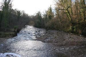
We reached a track called Straight Lane of ash and yellow lichens, where a man held a jug of eggs and complained that the hunt had chased a fox down the valley and it had got four of his hens. A shy courting couple eventually overtook and we reached the River Cover.
It was coat-stripping warm. Sunskew it is called above, the steep south-facing bank with midwinter bluebells spearing the warm moss. The water, though, looked cold, very clear, and steely grey.
On a rock, and on a glide, there stood a dipper, the national bird of Norway.
For a few minutes it flexed its legs and bobbed a most obvious white breast, then flew kingfisher-fast and low to another rock way up the Cover, where there’s a broad curve.
At a junction we asked a local walker about an out-of-bounds length of riverside and he said people go there skinny-dipping, and that you’d need to be SAS to get right through, probably because of the dripping rock faces. So one is deflected up, and we got views, jet stream sky and a half-hearted rainbow.
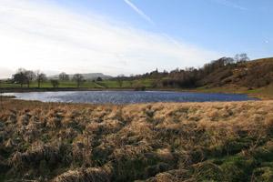
Hullo Bridge is a charming single-arched goodbye to the river, and then we headed for the moor. On the way up is a dish of a pond where ducks and others shuffled around the reeds and crags hang for crows.
Middleham Low Moor is a long ridge, a narrow quarter of a mile across, and the other side is Wensleydale. By the moor runs a gallop and racehorses thunder along this in the morning. Therefore this is an afternoon walk.
Directions
When in doubt look at the map. Check your position at each point. Keep straight on unless otherwise directed.
View a map of the Middleham country walk>>
1. From town centre cross and info board, cross road to archway below Richard III pub (Sign – toilet), paved path uphill 100 yards, right at junction, 200 yards. Track on left past eastern side of castle.
2. Pass bungalow on left, gate on left (waymark) to hedged path between gardens. Gate into field, squeezer, 11 o’clock over grasslands.
3. Right to track. On bend, keep straight on to grassy path, fieldgate into field, by wall.
4. Gate (waymark) on right to riverside path in wood. Steps. Stile (waymark) into field, gate (waymark) into wood, steps.
5. Stile (waymark) into field. Through ruined wall by river.
6. About 50 yards before next wall, usage route angles up grass slope, across a shallow gully and keeps to field edge around corner of wood (multi-waymarked post was elsewhere on ground in gully).
7. Stile (waymark) on left near end of wood, 20 yards, stile out. Across field then downhill by wire fence (old waymarked post).
8. Stile (waymark near Hullo Bridge) and straight on to grassy track that swings right and up and across grass. 9. Gate/fieldgate, cross road. pass Pinker’s Pond then 1 o’clock across grass 150 yards to path uphill from info board and via pairs of posts. Meet track.
10. On Low Moor turn right, head roughly towards castle. 11. At fingerpost on left and before town sign, cross road to grassy area with tree and sheepfold, gated squeezer (fingerpost) and immediately left through field. Gated squeezer, gate, pass castle, broken stile on left, cross field corner, gate and left to outward track and castle.
Fact file
Distance: Four miles.
General location: Yorkshire Dales.
Start: Middleham.
Right of way: Public and Open Access.
Date walked: January 2012.
Road route: Various.
Car parking: Roadside in Middleham.
Lavatories: Middleham.
Refreshments: Middleham.
Tourist and public transport information: Leyburn TIC 01969 622317.
Map: Drawn from OS Explorer OL30 Yorkshire Dales northern and central.
Terrain: Riverside and moor.
Difficulty: Moderate.
Please observe the Country Code and park sensibly. While every effort is made to provide accurate information, walkers set out at their own risk.


Comments: Our rules
We want our comments to be a lively and valuable part of our community - a place where readers can debate and engage with the most important local issues. The ability to comment on our stories is a privilege, not a right, however, and that privilege may be withdrawn if it is abused or misused.
Please report any comments that break our rules.
Read the rules hereComments are closed on this article