
GEORGE WILKINSON offers up a walk with a bit of adrenalin.
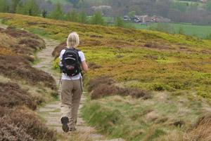
FACEBY magpies chivvied each other along a fence and my navigator said: “Let’s go.” Whorl Hill overlooks the village, a field away, and we climbed its smooth worn paths.
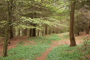
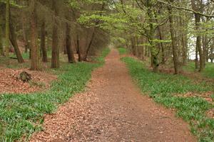
If you get a feeling of déjà vu, that is because we were here seven years since, but there was hardly blue yet from this notable bluebell wood, just a shaggy carpet of their green, a dozen flowers here or there in the sunniest southern spots.
But that was just a taster; this isn’t the usual bluebell walk. And off we tracked along Bank Lane, an eye on the para-gliders circling the sky over Carlton Bank like finely pencilled arched eyebrows, silent and hypnotic.
Nature though was rowdy, the lambs, wild geese and curlew and all the twitterers in the white flowering blackthorn.
The climb up the Cleveland escarpment was a new one for us and most pleasant, being very gently angled and with wood sorrel flowers scattered like snowflakes.
An old boundary stone has one side carved with an F and the other with a W and at the top a new sign read Welcome To The Raisdale Estate.
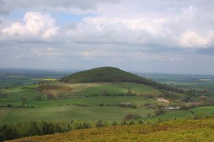
The surfaced Cleveland Way path took us over Round Hill; a family filmed grouse – the movie, while the grouse posed unconcerned. Down below was the round shape of our previous Whorl Hill, further was the sharp Roseberry Topping, and on the plains jazzed with yellow rape, a far belt of reflective Teesside industry. It was grand.
If the way up was a gentle surprise, the way down was a bit of a shock. The first leg was normal then, at an unsigned stile, we dived into a wood, a precipitous descent, between Little Bonny Cliff and Great Bonny Cliff which were invisible in the trees.
Actually I’d set a compass between these as the path wasn’t obvious at first, but shortly there were waymarks. At the bottom, slightly relived, we slurped into a big rhododendron bog, a strange ecosystem and soon to be ablaze with colour.
This refocused the concentration, firstly to avoid a sock soaking which we did, just, after a drought, and second because rhododendron is indeed invasive and closing in on the path.
Luckily its branches break easily with a satisfying brittle snap, although after a hundred yards or so our wrists ached; so keep up the good work, walkers.
We emerged to lovely land; the remains of a mill, gorse hedge, and flat tracks in, it had been a walk with a bit of adrenalin.
Directions
1. From the Sutton Arms, uphill through village, pass footpath sign on left, take lane on right, pass house ‘2 Church Lane’, pass church, on to drive, five yards, between posts to path between lawn and rockery, 25 yards (sign).
2. Stile and right diagonally across field, gate (waymark), left diagonally to stile by wood corner, path between wood and farm, snickelgate (waymark), stile, stile.
3. Snickelgate on left into wood (waymark), path uphill 300 yards. On right hand bend fork left, path was part obscured by fallen tree (no waymark), good path up through wood then down.
4. After boulders and gorse and about 25 yards from edge of wood, left to path downhill, path near edge of wood so fields to your right (no sign). Right fork to narrower path at edge of wood, five yards, sharp left-hand bend. Stile by bungalow.
5. Stile and right to lane, becomes track.
6. Fieldgate on right near old bench (bridleway sign), diagonally up across field, 200 yards, gate into wood, path angles right, uphill.
7. After wall remnants, boundary stone nearby, ignore a right fork.
8. Before old fieldgate left uphill on stone flagged path (no sign), 100 yards, gate to moor (waymark, info board), Cleveland Way stone path, 2/3 mile uphill, large cairn, half mile.
9. Left (waymark post) path down through heather, 100 yards, path by side of wood with wood on your right.
10. In dip and near tree on moor, look out for fallen wall and stile into wood (no sign), steep downhill, no obvious path but went via holly at ten yards then downhill 50 yards, cross contouring path to faint path downhill.
11. Cross grass track (waymark post), downhill through trees, sharp left (waymark post) to path 100 yards, diagonally right steep downhill to fingerpost, right.
12. Ford stream, 20 yards, left (loose waymark post) downhill. At fingerpost, across or skirt boggy area/track angling across right to path downhill by wire fence, boggy path through rhododendrons.
13. Stile/fieldgate, follow grown-out hedge, pass ruin, cross field, stile/fieldgate, track by wood, stile/fieldgate and bridge over stream, track, four successive fieldgates, left to road into Faceby.
Fact File
Distance: Five miles.
General location: Cleveland Hills.
Start: Faceby.
Right of way: Public.
Dogs: Legal.
Date walked: April, 2011.
Road route: From York via A19, A172.
Car parking: Roadside in Faceby.
Lavatories: None.
Refreshments: The Sutton Arms in Faceby.
Map: From OS Explorer OL26 North York Moors western area.
Terrain: Mixed.
Difficulty: Steep descent.
• Please observe the Country Code and park sensibly. While every effort is made to provide accurate information, walkers set out at their own risk.


Comments: Our rules
We want our comments to be a lively and valuable part of our community - a place where readers can debate and engage with the most important local issues. The ability to comment on our stories is a privilege, not a right, however, and that privilege may be withdrawn if it is abused or misused.
Please report any comments that break our rules.
Read the rules hereComments are closed on this article