
Harmby is a little village in Lower Wensleydale near Leyburn. It has the Pheasant Inn and, as it was raining, we took refuge.
A glass later and I’m looking at the jockeys on the walls, my navigator is talking to the landlord and it’s coming down in stair-rods. Luckily this is a fairly simple walk and with a very easy start.
The dead-end road took us a mile. The rain turned to sunshine, the Tarmac to track.
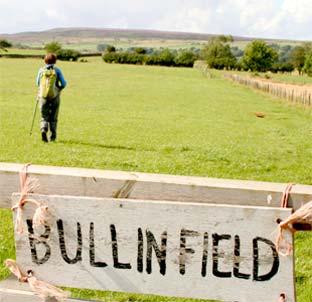
The land is more pasture than ploughed, nutritious lawns of grass and flocks of fit sheep.
Field boundaries are more of stone walling than hedge, dark stone with white lichens.
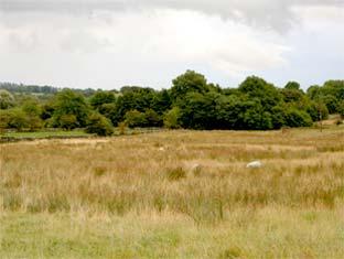
A gentle rise took us on to Harmby Moor, a shallow depression where red cattle lay down, the combine harvester had been rained off and we chewed our sandwiches and admired the views out from the valley to the far Hambleton Hills. Tranquil land, with just the occasional rumble of the Wensleydale Railway.
There was a bit of buzz after another mile, the busy Richmond to Leyburn road was near, further, and muffled by two miles, was the gunfire from the military ranges northwest but then we turned for the easiest of returns and the quiet again.
Two miles on Tarmac might put you off, but it’s been closed to vehicles for ages and the only traffic was walkers. One had a greyhound, there were plenty of hares. Another told us why the road was closed. So it was very pleasant, birds on a wire, Wensleydale in front and the mass of Penhill prominent.
If the walk had lacked drama then came the wake-up time. There’s a stone wall to the left and a local walker said she never looked over fearing to see a dead body. I was about to ask “have there been any?” but she hurried off, and my navigator took a step back from the edge.
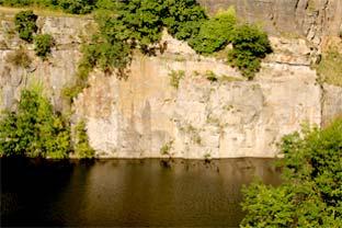
Actually it looks a good place for such disposal, not that I log such spots as I walk Yorkshire, but roll one over the wall and there'd be a longish silence then a splash, to leave but ripples on the dark water. On the surface were water birds with black, velvet-hooded heads. Gulls watched from ledges of the vertical rock. This abandoned and flooded quarry is the reason the road is closed to vehicles. The “danger of collapse” sign is relevant to lorries, not us. Actually there’s another part of the quarry the other side, not flooded but filled with caravans.
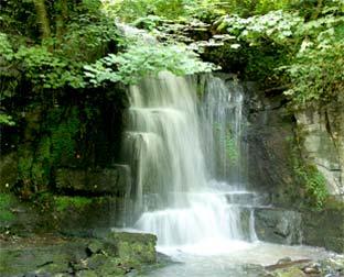
They are not visible so don’t have a Jeremy Clarkson moment and miss Harmby’s star attraction, a vigorous crash of a waterfall in a dark wooded nook.
Directions
When in doubt look at the map. Check your position at each point.
Keep straight on unless otherwise directed.
1 From Pheasant Inn, left to side road (brown caravan park road sign), bridge over railway line, fork right (dead-end road sign). Cattlegrid/fieldgate.
2 Immediately after the second cattlegrid/fieldgate, leave road for track on right (wall to left, hedge to right, no sign). Fieldgate into field, ten yards, left at corner to grassy track with wall to your left, stile/fieldgate into field, 200 yards on usage route by hedge rather than zigzag across field.
3 Stile on left (waymark far side), one o’clock across field but skirt marshy area, at far corner fieldgate into field and uphill by wall to your right, stile/fieldgate (waymark), fieldedge for 200 yards.
4 Gated squeezer/fieldgate on right (waymark), 200 yards between trees, stile/double fieldgates into field (waymark), 200 yards, stile on right and immediately left (waymark).
5 Stile/fieldgate and 11 o’clock on old boundary across corner of field (waymark), metal fieldgate below pens (no sign), one o’clock downhill to trees, fieldgate to tree-lined path.
6 Left to road, 500 yards, squeezer on left (fingerpost), by hedge, stile in fence (old waymark), five yards, footbridge, five yards, squeezer on right (fingerpost), uphill by wall to your left and skirt garden.
7 Left to ‘green dot’ route which is closed to vehicles at the bridge over the quarry and back to Pheasant Inn. Cross main road to side road, 100 yards on pavement, gated path on left at Harmby Pinfold with bench (signed), path to waterfall.
Fact File
Distance: Five miles.
General location: Yorkshire Dales.
Start: Harmby.
Right of way: Public.
Dogs: Legal.
Date walked: August 2009.
Road route: Road works on A1.
Car parking: Roadside and elsewhere in Harmby.
Lavatories: None.
Refreshments: The Pheasant Inn.
Tourist and public transport information: Leyburn TIC 01748 828747.
Map: Drawn from OS Explorer OL30 Yorkshire Dales northern and central.
Terrain: Low slopes.
Difficulty: Quite easy.
Please observe the Country Code and park sensibly.
While every effort is made to provide accurate information, walkers set out at their own risk.


Comments: Our rules
We want our comments to be a lively and valuable part of our community - a place where readers can debate and engage with the most important local issues. The ability to comment on our stories is a privilege, not a right, however, and that privilege may be withdrawn if it is abused or misused.
Please report any comments that break our rules.
Read the rules here