

George Wilkinson faces the wind and smoke on a hike around Westerdale.
Westerdale village and, after a chat with two walkers who were set on doing 11 North York Moors miles, we were off.
Snowdrops were out on the verges and an ash tree was uprooted in a gully.
The tower of Westerdale Hall is a very spooky mix of arts and crafts cum Gothic, it was once a "baronial shooting lodge".
On the pastures crows grubbed about at random and gleaming farm machinery was lined up.
We crossed the River Esk a few miles from its source. All in all, it was an interesting first mile on a dead-end road across the valley of Westerdale.
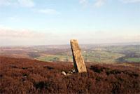
Sun was catching the tops and a fine climb up 400ft through a quilt of bilberry wound us up there to an old waymarker stone and ahead was the heather expanse of the moor.
We immediately retreated 50 yards down the slope because a southerly was whipping over, making it hard to talk or read a map. After that, and a proper draughtproofing of our coats, we tried again.
There is no track or obvious path right across the moor. We intended heading west to intersect at some point a track running at right angles, north to south, about a mile away. We could see a shooting box at one end of the target track.
However we didn't head straight for the box, Hart Slack is boggy and has mounds of club moss. Instead, we angled off to another and similar waymarker stone, this one fitted with a sheath of chicken wire. And then there was the lure of more characterful rocks, the bleeping of plovers.
In general, our route took smoothish ground through short heather and the result was an arc across the moor to the shooting box.
At the box, there was shelter and a view from behind its sandstone gable end. Also there was a thin distant plume of heather smoke. The box is equipped with a spring fed, stone lined, deepish trough that I presume is a dog wash. One shovel full of week-old snow lingered.
After sandwiches we accelerated, the track was smooth, became downhill, the wind behind. Stretching over Baysdale were views to the Cleveland Hills with Roseberry Topping looking like an iceberg.
The route parallels Baysdale, keeping high above it at a thousand feet. It takes with the valley a sharp turn to the east. The moor must be crossed again to get back to Westerdale.
Here it's called Great Hograh Moor, and once you're on the right path it's easy, with many cairns, some piled on top of large rocks, one is a named memorial.
Yes this stretch would have been lovely but for the few hundred yards through ground-hugging, throat-tickling heather smoke. This stuff was flowing into Baysdale, another plume was dropping into Wensleydale, Castleton was downwind.
More than 30 walkers, mostly the Which Way Walkers of Middlesbrough, were tramping back into the village, also just returning were the two who'd sped their sat nav and guidebook-guided 11 miles in the time we had wandered our obscure seven. I asked "did you get smoked". They said no but had seen five fires.
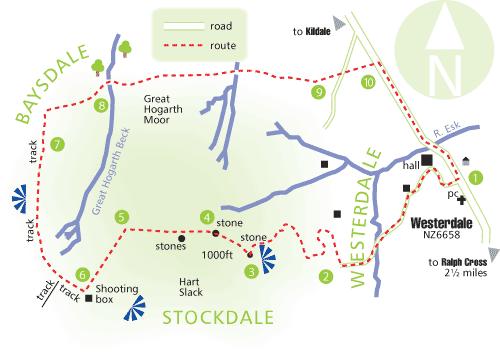
Directions
When in doubt look at the map. Check your position at each point. Keep straight on unless otherwise directed.
1. In village of Westerdale, dead-end side road with phone kiosk, crosses valley.
2. Fieldgate and right to track (fingerpost), curls uphill on moor.
3. At top, at waymark stone, track fades and ends. Head c290 degrees magnetic on faint vehicle mark lines for 300 yards.
4. From second waymark stone, head west, pass stone circle'. No obvious paths.
5. At about GR NZ 637055, angle approximately south-south-west.
6. Good track uphill from shooting box, ignore track on left after 200 yards.
7. At GR NZ 629061, good track on right (no sign).
8. Near beck ignore obvious deep-cut track to ford on right and take path ten yards on down to invisible little stone bridge by start of trees, 20 yards, ignore path by fence to left, head east uphill on path (cairns, no sign).
9. Cross road to path.
10. Right to road back to village.
Fact file
Distance: Seven miles.
General location: North York Moors.
Start: Westerdale village.
Right of way: Public and open access land.
Map: Drawn from OS Explorer OL26 North York Moors western area.
Dogs: Illegal.
Date walked: February 2008.
Road route: From York via Hutton-le-Hole, Blakey and the Lion Inn, then 1 miles and first left, after Ralph Cross, signed "Westerdale 2".
Car parking: Roadside in Westerdale.
Lavatories: Opposite phone box.
Refreshments: None.
Tourist and public transport information: National Park Moors Centre, in Danby: 01439 772737.
Terrain: Moor.
Points of interest: According to the OS map, a trig point on the moor in the middle of this walk.
Difficulty: A compass walk.
Please observe the Country Code and park sensibly. While every effort is made to provide accurate information, walkers set out at their own risk.


Comments: Our rules
We want our comments to be a lively and valuable part of our community - a place where readers can debate and engage with the most important local issues. The ability to comment on our stories is a privilege, not a right, however, and that privilege may be withdrawn if it is abused or misused.
Please report any comments that break our rules.
Read the rules hereComments are closed on this article