

George Wilkinson declines to follow the sun at Robin Hood’s Bay.
Robin Hood's Bay shone with sunlight with too much reflected brightness, so we turned away, passing the Victoria Hotel, the windows advertising 'vacancy', 'no vacancy', then a sombre church where rooks ferried nest sticks, to our track.
These days it's called the Cinder Track. Once it carried a railway for perhaps a summer day out in the bracing sea air.
We forgot the sea for the next three miles. The track curves through cuttings, some a suntrap and some shady, where harts tongue and ferns spread and lords and ladies flourish.
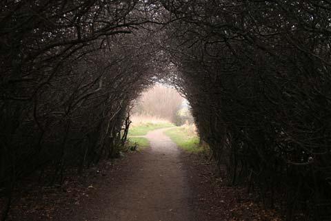
Along embankments over wooded valleys the track is in the tree tops. Catkins carpeted the cinder. Trees arch over in a spring time tunnel of bird love, a woodpecker drummed.
There will almost certainly be other walkers and, more pertinent, cyclists. The speediest wheelers will be visible coming towards you as the track walked this way is generally uphill.
A woman fed chopped apples to, she hoped, micro pigs.
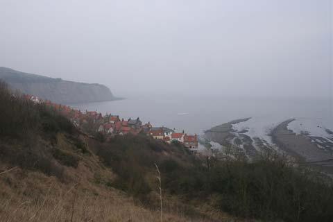
Eventually we got the big views, to Ravenscar further and higher. Much land is landscaped by the alum shale quarrying and alum manufacturing works which took place from 1640 to 1862.
Inland, there rises steep, quarried high land, now burnished by gorse. The works site is green, pleasant and National Trust to the sea.
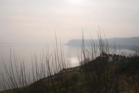
We strolled down through Trust scrub to the cliffs. The sun was opalescent and the horizon was soft. The white-painted buildings of Robin Hood's Bay were just visible, two miles over the water.
A deer walked gingerly along a typically fragile and precipitous cliff edge. The sea was receding quickly, showing sharp nabs and scars of rock that jut straight or angled, and some that curve like ribs in echo of the cliffs.
A shadowy cormorant skimmed, there were no waves. Oystercatchers fed on the beach, then flew around flashily.
Dandelion yellow coltsfoot flowers were scattered cheerfully and some were riding on slabs of slipping and slumping cliff to a chance lower down.
We had three reasons for doing this walk anticlockwise, the aforementioned sun and cyclists, and now, and most important, the sea. Because at Boggle Hole, or previously at Stoupe Beck, you have the choice of the high path or the beach back to Robin Hood's Bay. So do check the tide times.
The tide was out and ebbing and the beach was lovely, with bands of sand, acres of smooth shale and barnacled rock. Also, note, the National Trust describe Boggle Hole as a “precipitous inlet”, and climbing out for the high path involves interminable steps.
But, as a reward for that effort, there is more terrific Cleveland Way path engineering and a pretty view of a Robin Hood’s Bay cottage cascade.
Directions
When in doubt look at the map. Check your position at each point. Keep straight on unless otherwise directed.
View a map of the Robin Hood’s Bay country walk>>
1. From car park by roundabout, left to road uphill. First left to Thorpe Lane, pass church.
2. Metalled track on left (fingerpost 'Cinder Track'), becomes cinder. Gate/fieldgate, cross road. 3. Stationmaster's House, 200 yards, bench, steps or track to cross road. Rejoin cinder track.
4. Cross concrete drive, 300 yards, stile on left (white on green waymark, plaque), path downhill through scrub then angles right across pasture. Stile/fieldgate and left to track, 200 yards. Leave track and fork right to path between hedge and fence, (fingerpost Cleveland Way, Robin Hood's Bay). Cliff top path.
5. Squeezer and right to road, downhill, path downhill from Stoupe Bank Farm (fingerpost/ waymark).
6. Footbridge. Option to take beach to Robin's Hood Bay if tide safe. Otherwise steps uphill. Path. Steps downhill to Boggle Hole, right to road for ten yards, engineered path on left.
7. Footbridge and Boggle Hole Youth Hostel. Option of more beach walking. Otherwise steep up many steps (National Trust sign), thorn arch, fenced path, right at small fieldgate (waymarks).
Stone-flagged path, steps and wooden walkways down. Sea wall with benches, steps up to left, down between cottages. 8. From bottom, left road fork, steep uphill, then pavement and steps, to car park.
Fact file
Distance: Seven miles.
General location: East coast.
Start: Robin Hood's Bay.
Right of way: Public and permissive.
Dogs: Legal.
Date walked: March 2012.
Road Route: From Whitby or Scarborough.
Car parking: Roadside or village top pay and display car park.
Lavatories: Car park and bottom of village.
Refreshments: Robin Hood's Bay.
Tourist & Public Transport Information: Whitby TIC 01723 383636.
Map: Drawn from OS Explorer OL27 North York Moors eastern.
Terrain: Cliff top.
Difficulty: Moderate.
Please observe the Country Code and park sensibly. While every effort is made to provide accurate information, walkers set out at their own risk.


Comments: Our rules
We want our comments to be a lively and valuable part of our community - a place where readers can debate and engage with the most important local issues. The ability to comment on our stories is a privilege, not a right, however, and that privilege may be withdrawn if it is abused or misused.
Please report any comments that break our rules.
Read the rules hereComments are closed on this article