
MANY of the old roads and pannierways on the North York Moors have a secret to tell about their history and the people who lived and worked near them.
Some were moor coal roads, turf roads or corpse roads. When you cycle along these roads and tracks, you can imagine the difficulties that travellers must have endured, especially with a north-east wind blowing from the coast.
Guide stones and posts were scarce until the 18th century when a law was passed for posts to be erected at all crossways in the North Riding. The roads were travelled by packhorses, sometimes 40 animals long with their wicker baskets carrying coal, peat, charcoal and stone.
But it was the monasteries which were organised, transporting wool for export, and from Whitby they developed a large fishery trade. It is thought that many of the packhorses were bred at the Yorkshire monasteries of Whitby, Guisborough and Rievaulx which held a monopoly in this trade for many years.
As you cycle along the moors you ride on an old medieval road called Turngate. Nearby, at Turngate Hill, an excavation was made by Canon Atkinson, a local preacher, while he was investigating tumuli and a ring cairn. What he found there revealed a strange and gory secret. The remains of no less than 16 cremated bodies were found lying under the moor.
So as you cycle past this historic site, which is on the left as you approach the road on Turngate, give a thought for the poor souls of hundreds of years ago lying under the heather, and wonder how they came to be cremated and buried in this inhospitable place.
Your route
Leave the moors centre car park, turning left onto the road. Just past the railway bridge, turn right to Duck Bridge. Go right here onto a narrow road. The road twists and turns as it climbs and falls and soon you reach Ainthorpe village.
Turn left at the T-junction, then continue along through the village until you see a sign for Botton and Danby Church. Go left here towards open countryside. Ride along Danby Dale and enjoy the scenery as Danby Rigg towers above you on your left as does Castleton Rigg on your right.
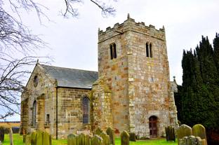
Soon you will see Danby Church on the right in its beautiful setting, seemingly miles from civilisation. The church is usually open and has some unusual features and even a church cat. Continue along the dale as the road twists and turns passing through a farmyard along the way. Eventually you approach Botton. Watch out for the sharp corner and follow the road right here signed to Stormy Hall Farm.
Downhill now, then a long, severe climb past Stormy Hall to a T-junction at the top of the lung-bursting hill. Turn right here onto the main road, then in about half a mile, go left onto a very narrow, bumpy and twisty road.
Keep on this road without deviation, watching out for steep hills and nasty corners as it twists and turns on its lonely way, eventually past two houses to a T-junction. Go left here downhill with care on this narrow road. At the junction keep straight ahead and soon you arrive at Westerdale village. Turn right here signed to Kildale and Stokesley down a steep descent.
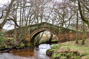
At the bottom of the hill, at the modern road bridge, take time to stop and look along the beck from the bridge to a grand packhorse bridge amongst the trees. The bridge was presumably once part of the road but now gives access to a field.
A long climb now for two miles, then a serious descent through a ford before climbing again. Keep straight ahead, still following signs for Kildale and Stokesley to the top of the hill. If you look ahead now you can see the top of Roseberry Topping on the horizon and to the left, Captain Cook’s monument.
Descend again. Observe the use of the collection of toilet pans at the farm on the right. Continue along past the house with the Yorkshire flag, then ascend to a crossroad to turn right, signed to Commondale and Castleton.
After an ascent and two descents, you reach Commondale and the Cleveland Inn public toilets on your left. Ascend steeply out of the village and cycle along to the main road crossroads. Go straight ahead here onto the rough road of Turngate. Watch out for large potholes they might have a crocodile in them.
Pass Job Cross on your left and a little further along, Turngate Hill is on your left near the burial site. Turn right here, then in a few hundred yards, go left onto a narrow road across the moor to reach the new Danby Beacon. Left here onto another rough old road. Cycle along to the end, then turn right towards Lealholm. Take care at the steep descent into Lealholm and before you reach the bottom, just past the school and car park, turn right signed to Danby. Cycle along past the tearoom, then uphill again to leave the village.
Continue along this twisty road as it crosses the railway track twice to reach Houlsyke. Cross the railway again, then follow the road all the way back to the moors centre.
The Facts
Distance – 28miles/45km
Terrain – Very hilly, lots of steep ascents and descents
Best map – OS Landranger 94
Start/grid ref – Moors Centre car park Danby, grid ref: 717084
Refreshments – Moors Centre, Cleveland Inn
Commondale, tea rooms and pub at Lealholm
Public toilets – Commondale and Moors Centre


Comments: Our rules
We want our comments to be a lively and valuable part of our community - a place where readers can debate and engage with the most important local issues. The ability to comment on our stories is a privilege, not a right, however, and that privilege may be withdrawn if it is abused or misused.
Please report any comments that break our rules.
Read the rules here