
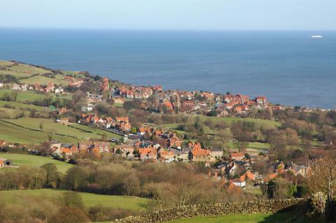
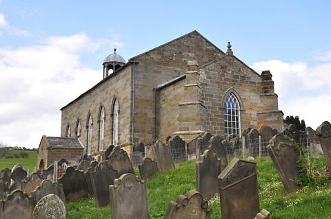

THE Old Church of St Stephen of Fylingdales stands on a hill as you leave Robin Hood’s Bay travelling north at the junction of the B1447 and a minor road leading to the village of Raw.
It has a commanding view across Robin Hood’s Bay to the sea, with which it has many a tragic connection.
Inside the church is a list of rescues carried out by one of the lifeboats and in the churchyard many strangers lie, memorials to shipwrecks along the Yorkshire coast.
The first church built on the site was in the early 12th century, and since then churches have been pulled down, rebuilt, storm damaged and restored. There are a few Norman windows in the church and a Norman font was found buried in a nearby field.
The current church is a plain affair from the outside, but take a peep through the door and you will be delighted by the 18th century box pews. Above the pews is a gallery, which was once reached via an external stone staircase, this was a feature of many other churches in the area.
There is also a three-deck pulpit, no doubt for the vicar to keep an eye on any unruly parishioners in the gallery.
At the west end of the church is the west gallery, perhaps it should be called the west mezzanine. Inside a glass case you will find the remains of an old harmonium which was used until the 1940s. There are also a couple of barrels from a barrel organ which was used for music in the church previous to the harmonium.
There are many more interesting features inside this tiny church and around the walls which I will leave for you to find out for yourselves, except one which I will tell you about – The Maiden’s Garlands.
Many years ago you would have seen these strange artefacts hanging among the cobwebs above the pews, they were made by friends of deceased young women who had died before marriage.
They would be carried by girls of a similar age as they solemnly walked in front of the coffin during the funeral procession. But this funeral was not carried out in total sadness, as the deceased had now become a bride of Christ which was cause for some celebration.
The maiden’s garlands have been described as creepy, scary and frightening. They are made of calico and colourful ribbons over a hooped frame.
After use they were hung from the roof of the church but after manyyears they became dirty and delicate.
The garlands, after hanging there for more than 150 years, were removed and cleaned and are now hanging in a cabinet at the west end of the church, when you take a look don’t be surprised if you feel a shudder down your back – they do have a ghostly look about them.
Your route
Leave the car park at Robin Hood’s Bay to cycle across the main road into Mount Pleasant North following the sign for Cinder Track.
At the top of the street, bear left to follow signs for Cinder Track and Cycle Route number one, then bear right onto the track.
You need little guidance along here so keep on the track to the crossing at the main road. Cross the road at the crossing provided to continue along the track.
Eventually you approach Whitby at the entrance to the famous viaduct.
Turn right here to leave the track and viaduct, then keep right to the road. Go right again to soon start a serious descent down what is known locally as Danger Hill – you will soon find out why.
Continue along this scenic route to Ruswarp, then go right at the Tjunction over the iron bridge across the River Esk.
Once over the bridge you need to take a detour if you are going to indulge yourself with a delicious butcher’s pork pie. The shop is a 100 yards up the road into Ruswarp on your right.
Those of you not needing food, turn left just after the level crossing signed to Sleights and Pickering.
There are two cafés along this road, one on the right the other at Briggswath at the garden centre.
At the T-junction at the end of the road, go straight ahead across the A169 to cycle along the drive of the St Oswald’s Pastoral Retreat Centre, also signed with a blue sign as the National Cycle Route 52 to Aislaby.
You soon start to climb which becomes steeper as you cycle along passing a house called Woodlands.
Continue climbing past St Oswalds, watch out for the water gully on the road here.
Soon the road ends, exit through a small gate here onto a bridleway and continue climbing past a seat and keep following signs for Aislaby.
Bear right at the junction of tracks signed Aislaby and eventually you end your stiff climb at Aislaby Village. Go left here past the public conveniences, then keep left when the road forks signed to Egton.
Cycle along for about three miles on a narrow twisty road keeping straight ahead at all times until you reach a T-junction. Go left here onto a wide road to cycle along to Egton where there is refreshment available at either of the two pubs in the village.
Cycle past the pubs, then turn left signed to Grosmont and Sleights.
This twisty, narrow road descends for a couple of miles, very steeply at times take care.
Eventually you cross a narrow bridge, then cycle along to Grosmont. There are toilets and a café as you enter the village. You then start to climb past the railway station and through the village.
Almost at the top of the hill, bear left signed to Sleights and Whitby and continue along this twisty road with many ascents and descents to finally reach Sleights. There are toilets on the left as you approach the T-junction.
Go left here signed to Whitby, then take the right turn signed to Ugglebarnby and Littlebeck.
Another steep descent down to the bridge at Iburndale, then a long, tiring ascent through Ugglebarnby to a T-junction.
Go left here signed to Scarborough and Whitby to cycle along to the main road. Go left here signed to Ruswarp and Whitby. Cycle downhill and not far you will arrive at double bends where you must turn right signed to Sneatonthorpe and Hawsker.
Enjoy this quiet, twisty road and watch out for the ford if it is in flood. Keep straight ahead at all times, following signs for Hawsker and Scarborough.
At the A171 crossroads, go straight ahead signed to High Hawsker, Fylingthorpe and Robin Hood’s Bay. At the T-junction, go left, then right signed to Robin Hood’s Bay and Fylingthorpe.
Continue along for a couple of miles, then start a severe descent.
Look out for Fylingdales Church at the apex of the Raw road junction and take a look inside, you will be pleasantly surprised. Leave the church, then keep on down the steep hill into Robin Hood’s Bay and the car park is on the right.
The facts
Distance – 25miles/40km
Terrain – Serious ascents and descents
Best map – OS Outdoor Leisure 27
Start/grid ref – Robin Hood’s Bay, grid ref 950055
Parking – Large car park at Robin Hood’s Bay
Refreshments – Plenty in Robin Hood’s Bay, cafés and pub at Grosmont, two pubs at Egton, two cafés on road between Ruswarp and Sleights. Good butchers at Ruswarp with top class pork pies and bacon sandwiches, highly recommended
Public toilets – Ruswarp near the iron bridge along Sleights road, Grosmont, Aislaby and Robin Hood’s Bay


Comments: Our rules
We want our comments to be a lively and valuable part of our community - a place where readers can debate and engage with the most important local issues. The ability to comment on our stories is a privilege, not a right, however, and that privilege may be withdrawn if it is abused or misused.
Please report any comments that break our rules.
Read the rules here