

George Wilkinson heads to Rosedale Abbey but turns the ‘other way’ into Hartoft Rigg.
HARTOFT RIGG overlooks Rosedale, that grand valley, but we turned the other way, into Hartoft Dale that is much smaller, quiet and isolated.
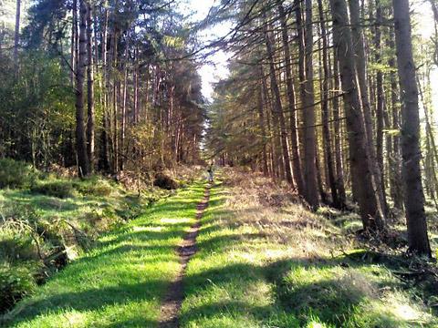
The slope down was gentle and included an SSSI of ‘dwarf shrub heath’. But much of the valley, much of the North York Moors east of here, is mature conifer forest. So all afternoon we alternated between sky and trees, which was nice on a fair autumn day.
Coming down from the rigg we’d given thanks, as we diced round boggy bits and rivulets, we hadn’t been here the day before, when there had been hard rain.
At the bottom of the valley, where a side stream joins Hartoft Beck, these sentiments returned. Although the ford was passable and has an attendant footbridge, the nearby footbridge over the extravagantly named Priest’s Sike Slack is but a simple low thing of concrete railway sleepers propped on a mid-water rock and could be a sock wetter.
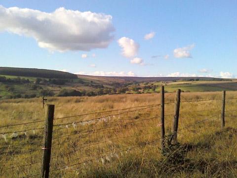
Don’t be put off, especially as the authorities have, most usefully, installed a lot of new waymarks as the ways are intricate and have been adjusted and added to recently. So we followed the arrows up the other side of the valley, which is rougher pasture, up to the tree line.
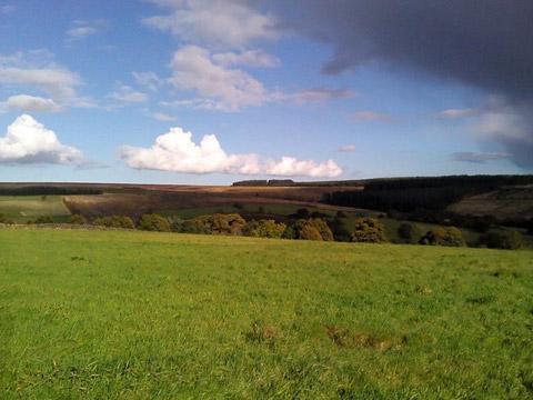
Here there was a flooded bench, where we sat. Behind us there was a curtain of conifers and in front the best view of the valley detail. We propped out feet on rocks. There was no sound from the few farms, the few houses, or the score of fields that, to the look of it, make up Hartoft Dale.
Then after a late lunch, a tractor started, cattle moaned and shotguns fired from a mile or so north. Fly agaric mushrooms, the notorious red and white spotted ones, clustered under the conifers.
We took the path along the tree line, the best part of a mile along the valley, all the way to its heavy-duty part where the aptly named Rock House is a stone merchant’s yard. Our route came down past gorgeous autumn colours of ancient woodland to another ford, which also has a pedestrian bridge. Here in 2010 a woman died when her Land Rover was washed downriver.
On a brighter note, lost in the back lanes, were two women in an Audi, their dresses 1940s style, searching for a Second World War party in the forest; the navigator/passenger held, rather than a martini, a more practical can of Kronenbourg.
We took a sedate but pleasant Forestry Commission permissive track, and then reached our final lane. Traffic was entirely agricultural. My navigator wrenched open a recalcitrant gate for a tractor and muck spreader; a ‘typical farmer’s gate’ she joked, and the farmer laughed and said the National Farmers Union advised that any non-public gates at a road should be as awkward as possible to deter rustlers and poachers.
The exact mile of lane is dead straight and very pleasant, an old sign read ‘Slow Down Deer!’, and tall dandelions types were the last flowers.
DIRECTIONS
When in doubt look at the map. Check your position at each point. Keep straight on unless otherwise directed.
1. From parking area at Hartoft Rigg (information board), right to road and through white painted gates with cattlegrid and immediately gate on left (waymark/footpath sign) to path in heather – path is indistinct so use adjacent track. Gate, grass track.
2. Stile/hurdle (waymark), path through wood near right-hand edge.
3. Path on right (waymark post), ten yards then path swings left by edge of wood, downhill, gate (waymarked post), into field, downhill by wall, stile and steps (waymark post).
4. Left to dead-end road, 50 yards, right downhill on dead-end road before house. Footbridge/ford, right across grass for 50 yards, concrete footbridge and left to path by stream (waymark post), 50 yards, path swings right 30 yards up bank, stile into field, (waymark post).
5. Uphill near wall to your right, 200 yards, waymarked post and immediately broken stile and slab footbridge over ditch into next field then 2 o’clock for 50 yards to waymarked post and left uphill by wall, pass waymarked post. Keep to left of wall remains.
6. Fieldgate near bench and right to wood-edge path (waymarked post), becomes track inside wood edge for a stretch.
7. Ten yards before fieldgate and near a waymarked post, take unsigned path on right, 25 yards, gate (waymark) into field and downhill by wall to your left, straight on through farmyard, pass house, concrete drive, footbridge/ford to dead-end road steep uphill.
8. Right at junction (nearby telephone kiosk). Fork left to grass/stone track (black waymark, 200 yards, forest gate (information board) track in wood.
9. At multi-route junction, cross track to path (black waymarked post), uphill. Right to road.
FACT FILE
Distance: Five miles.
General location: North York Moors.
Start: Hartoft Rigg.
Right of way: Public and permissive paths.
Dogs: Legal.
Date walked: October 2012.
Road route: From York, via Cropton, immediately after the Blacksmiths Inn turn right (Hartoft ¾ Egton 11), 500 yards, turn left (Egton Bridge 10 ¾), 1½ miles.
Car parking: Free car parking area by cattlegrid (info board) at Grid Reference SE740957.
Lavatories: Rosedale Abbey.
Refreshments: Rosedale Abbey and the Blacksmiths Hartoft.
Tourist & Public Transport Information: Pickering TIC 01751 473791.
Map: OS OL27 North York Moors eastern area.
Terrain: Valley.
Difficulty: Moderate.
Please observe the Country Code and park sensibly. While every effort is made to provide accurate information, walkers set out at their own risk.


Comments: Our rules
We want our comments to be a lively and valuable part of our community - a place where readers can debate and engage with the most important local issues. The ability to comment on our stories is a privilege, not a right, however, and that privilege may be withdrawn if it is abused or misused.
Please report any comments that break our rules.
Read the rules hereComments are closed on this article